1820m - 31.5 km (Lago d’Idro (Sant’ Antonio))
1970m - 32.2 km (Lodrone/Cerreto)
1663m - 31.5 km (Lavone)
1874m - 27.7 km (Breno)
1911m - 29.3 km (Esine)
1932m (1942m) - 30 km (27.8 km)
(Cividate Camuno (or short-cut))
310m - 7.6 km (Passo di Croce Domini)
529m - 9.8 km (Passo/Giogo del Maniva)
This is west of the Lago di Garda and the Dolomites and is a truly spectacular mountain road from Lago d’Idro to Passo di Croce Domini (1894m). From Breno (330m), Esine (293m) or Cividate Camuno (272m) in the north via Passo di Croce Domini it is a gravel road for 5.6 km before the tarmac returns before climbing up to Passo di Vaia (2114m) (65m gravel off the main road) and the highest point of the road at (Goletto del) Giogo della Bala (2136m) (only 425m gravel from the south). Dosso dei Galli (2188m) is the highest point that is asphalted on a closed military road (but you can get through with a bicycle) that starts at the Sella dell’Auccia (2108m) pass (80m - 0.9 km).
It is a quite long and hard climb from any side. One could also climb the nice road from Bagolino via Goletto Gàvero/Goletta del Gaver (1796m), Goletto di Cadino (1937m) and Passo di Croce Domini. Most will arrive via the crossroads at Passo di Maniva/Giogo del Maniva (1660m) on the south side.
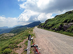
The recommended approach is via Anfo (404m) by Lago d’Idro (the small road takes off just north of Anfo). This road is very hard, very interesting and very beautiful. It is sign-posted for the Maniva pass with a blue sign. This road has a flat gravel part for ca. 1.2 km, which is a bit dusty and stony (possible to handle with a road bike, but be careful … ). This section was blocked by a landslide in June 2004 and the route was cleared again in 2009, but only the tunnels has been minimally improved since before. The gravel section is the most wonderful place on the whole road. Road quality overall has deteriorated a bit for the last 10 years.
One could also climb from the west from just below Bagolino (712m) from Ponte Prada (611m) and Ponte di Destrone (737m) up a somewhat steep road via Giogo del Maniva (1660m) to the pass. One could start already down near Lodrone (385m) on a small and nice road to Bagolino (via Riccomassimo and Cerreto (878m) (probably only directions for these villages)) or on the bigger main road (SS669) that starts further down at the Lago d’Idro (also nice) and both these roads to Bagolino descends a little before they climb again near or in Bagolino. The easiest and seemingly the most boring approach is via Lavone (508m) to the west.
A NATO-built radar station at the top of Dosso dei Galli looks exciting (it was abandoned in 1995). It was the for this station that the top section of the road got asphalted. Bring water on the climb from Anfo as it is usually hot down there and no water before the bar at Passo di Baremone/Passo del Mare (1418m). There are two bars at the Maniva pass and only one place to get water along the gravel road to Passo di Croce Domini. This road is rideable with a road bike without too much trouble (worst near Croce Domini). I am not totally sure the “short-cut” road from Cividate Camuno is practicable with a road bike.
Here a list of all the passes on the road from Anfo (404m) to Bagolino (712m) in order: Cuca Chetoi (911m, near the road); Cuca del Frinc (1288m, near on private road); Passo di Baremone/Passo del Mare (1418m); Passo della Spina (1521m); Passo della Berga (1527m) (gravel, asphalt starts soon after); Passo del Dosso Alto (1727m); Passo di/Giogo del Maniva (1660m); Passo del Dasdana (2086m) (actual pass 2070m, 50m below on a path); Goletto delle Crocette/Goletto di Ravenola/Passo di Dasdana (2072m); after a descent to 2051m comes Sella dell’Auccia (2108m) (road to Dosso dei Galli (2188m)); (Goletto del) Giogo della Bala (2136m) (425m gravel from the south); Passo di Vaia (2114m) (65m gravel road); Passo di Lavena (1992m) (gravel, might not be a correct pass!); Valico Poffa di Rondenino (2012m) (gravel); Passo di Croce Domini (1894m) (asphalt returns); Goletto di Cadino (1937m); Goletto Gàvero/Goletta del Gaver (1796m).
The road to Passo di Rondenino (2040m) from the gravel road between Croce Domini and Giogo della Bala has been surfaced in part with stones and is partly possible to cycle up even with a road bike.
See also: Passo del Dosso Alto, Passo di Croce Domini, Goletto di Cadino and Goletto Gàvero/Goletta del Gaver
[IT-BS-0911, IT-BS-1288, IT-BS-1406, IT-BS-1525, IT-BS-1522, IT-BS-1727, IT-BS-1664, IT-BS-2070, IT-BS-2071, IT-BS-2103, IT-BS-2162b, IT-BS-2113, IT-BS-1984, IT-BS-2011, IT-BS-1892b, IT-BS-1943, IT-BS-1795, BIG 742]