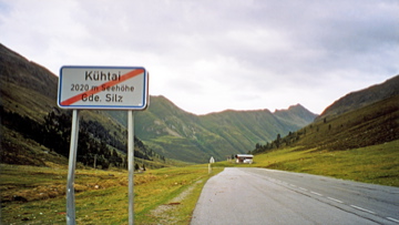
Sign 2020m
1396m - 23 km (Kematen); 1081m - 17.1 km (Sellrain)
[AT-7-2017, BIG 610]
 |
Height | Climbing height - length |
| 2018m Sign 2020m |
1237m - 17.7 km (Oetz); 1490m - 19.2 km (Haiming via Sattele) 1396m - 23 km (Kematen); 1081m - 17.1 km (Sellrain) |
|
| Difficulty | Beauty | |
| 4 (5) | 2-3 (5) | |
| How to get there | From the west it is a long and varying climb from Oetz (781m). There are a few short steep sections (one is around 17%). The possibly hardest approach would be to take a small road from Haiming (679m) to the north via Sattele/Silzer Sattel (1690m) to Wald (1539m) and then up to the pass. The eastern climb is quite steep above Sellrain (up to ca. 16%) and for longer stretches than on the west side. The climb starts in Kematen (621m) or in Sellrain (937m), if you come via Axams here (a recommended road). One could go higher up to the Speicher Finstertal (2343m/(2325m)) with gradients up to 20% and with a tunnel that could be locked at times (22.2 km/1814m from Haiming). | |
| Other comments | The nicest parts of the pass road is just before the pass on the west side and the part above Sellrain on the east side. Going down the east side you could gain some real speed and it may well be the pass road in the Alps where you could gain the highest speed down. I wheeled down without any effort in 91 km/h and could easily have gone faster (I’m just not used to that high speeds). I believe they can go above 100 km/h down here in a race like the Ötztaler radmarathon (I was taking part in this race in 2009, but some cyclists were in the way so I could not go faster than before). The road is good. There are restaurants and hotels at the resort at the pass but it all looked rather gloomy and mostly closed down when I was there in the Summer of 2003. There is a bar in Wald on the west side. [AT-7-2017, BIG 610] |
|
| Map |
||