1404m - 17.13 km - 8.2% (Queige)
1276m - 14.22 km - 9.0% (Les Perrières)
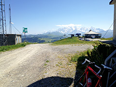
1236m - 13.48 km - 9.2% (Villard-sur-Doron)
1241m - 18.04 km - 6.9% (Manant)
837m - 11.55 km - 7.3% (Hauteluce)
1543m - 21.38 km - 7.2% (Ugine (south))
1515m - 20.21 km - 7.5% (Ugine (east))
You can start the climb already down in Albertville (346m) and take off up the mountainside at Queige (537m) for a long and varying climb. I guess there are some steep stretches here, but it is not the steepest approach.
The climb from Les Perrières (665m) join up with the road from Queige and then goes the same way to the top. A bit further up the valley you come to the steepest road up to Mont Bisanne with 9.2% for 13.5 km. It starts in Villard-sur-Doron (705m) and at two places along the way you could choose to take a smaller road, but only the first alternative is shorter/steeper, but the second one could also be a nice alternative to the main road.
If coming down from (Col du) Cormet de Roselend (1969m) or possibly the gravel pass Col du Cormet d’Arêches (2106m), then one could take the main road toward Col des Saisies (1658m) at Manant (700m) below Beaufort. One turns off the Saisies road at 1575m. If you have been up to the nice Col du Joly (1989m), you start the climb in Hauteluce (1104m).
If coming from Ugine, you have some choices and you can start climbing at once either from the road to Albertville (Ugine south (398m)) or on the road to Megève (Ugine east (426m)). These roads soon meet up and give you a long and varyingly hard climb on a forestry road (which might not be totally perfect all the way).
[BIG 281]