1760m - 21.5 km (1516m - 17.8 km) (1212m - 13.8) (Klausen/Chiusa)
1955m - 20.7 km (Bolzano/Bozen)
1955m - 18.9 km (Bolzano/Bozen via Signat)
1993m - 20.7 km (Bolzano/Bozen via Sta Maddalena)
1903m - 20 km (Kollmann/Colma)
The best way to go up to Rittner Horn/Corno del Renon with a road bike is via the Villanders/Villandro area. Both roads up here suggested avoids going through the Villanders village at the price of climbing pretty steep and narrow shortcut roads. I have only climbed up via Kalchgruber and the shortcut before reaching Villanders is a concrete road with gradients up to around 20%. The road from Klausen up to Gravetsch looks to have similar steepness for the shortcut part.
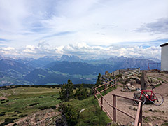
Even if you took the easy way through Villanders, this will be a quite hard climb first to Gasser Hütte (1750m) (restaurant) and then easier but on gravel road to Gasteiger Sattel (2056m). From this big sattel there is a rather hard ramp to conquer before it will be easy going again until the turn-off for the top of Rittner Horn. That last part had two places where I had to use all my strength to not having to walk, but otherwise it was just fine. The views from the very top are outstanding.
I have previously described the most gruelsome way up to the end of asphalt on the way up from Bolzano/Bozen (305m) and the other alternatives on that side to the Rosswagen (1702m) pass, so see that for more information on the south side climb. However the gravel road from Rosswagen has a steeper section that is not very good. I could cycle down here without too much of problem, but not sure how easy it would be to climb. This side is 6.2 km gravel, while the northeast has 7.7 km (and 51m less elevation gain). When you get out of the woods the road becomes better. Above Unterhorn (2024m) (which is also a pass) there is a restaurant.
[IT-BZ-2054]