Sign 2315m
The climb starts on the same road out of Briançon (1212m) as the climb up to Col d’Izoard (2361m). After a series of bends you get out of Briançon and come to a place where an asphalted road takes off to the left. That is NOT the road to take. The one you will be looking for is a bit higher up along the road going off left – a road that goes almost straight ahead rather than left really, but on the left side of the Izoard road. It is a small, rather rough, military road that does not seem likely that it would take you up the mountainside (it is closed to cars). It soon starts to wind its way in a seemingly endless series of hairpins. The surface is very poor (I think it was gone in one little tunnel). There is no problem to get up on a road bike, but you do not really look forward to descend the same road again. The road is a bit better higher up.
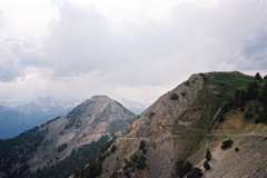
It is a little hard to guess where you are heading, but take a guess on one of the higher points of the mountain that you could glimpse from below and you will not be totally wrong. The pass is at the point where the tarmac ends (which is at a crossing on the plateau far above). It seems like you reached the pass earlier on, but there is no road or even obvious path down the other side here, so the real pass is reached when coming to another ridge here. It is possible to descend this pass on the other side on the unpaved road going right here (but if it is all practicable with a road bike, I cannot tell for sure). There are also other unpaved road variants going up from Briançon, but they may not be good enough for a road bike. It is 12.4 km from the Izoard road to the pass.
The pass is only signed at the walking pass (at quite another location) at 2315m. However, the road effectively functions as a road pass between the same valleys, but is less direct and around the other side of the Sommet des Anges (2459m).
There are absolutely NO water on the way up at all and it is a very dry, hot and long road up here! If you want to explore the rough-stuff roads around here, you should get hold of a good map (like IGN 1:25 000) of the area. The main road ahead at the pass height should go down near the Col de Montgenèvre/Colle del Monginevro (1851m) on the French side of the pass, but I am not sure whether it would be easy with a road bike or not (as I have heard different stories and not tried it myself). There are very good views around the top over the Briançon area and the forts, and also of the Janus fort still higher up (which one could visit for even grander views).
[FR-05-2347a]