Sign 1785m
879m - 16.48 km (Flumet)
1064m - 15.90 km (Gorges de Arly)
1087m - 16.72 km (Manant)
683m - 10.25 km (Hauteluce)
You have to go via Col des Saisies (1658m) on all surfaced climbs here. There are many alternative roads one could take to get here and I do not list every possible variant. If coming from Col des Aravis (1486m) you start in Flumet (908m). If coming over Megève (also a pass – Seuil de Megève (1107m)), you start in Frassette (957m).
If coming down from (Col du) Cormet de Roselend (1969m) or possibly the gravel pass Col du Cormet d’Arêches (2106m), then it is logical to start the climb on the road from Manant (700m) below Beaufort.
If you have visited the nice Col du Joly (1989m) (which has lovely views from the top) then the climb starts in Hauteluce (1104m) and it is short and easy.
If you prefer to climb up here from the north when coming from Ugine, it would be best to continue up toward Megève and turn off in the Gorges de Arly (740m) up to Crest-Voland. (You may have taken the high-going D109 road from Ugine and if so then this turn-off is a few hundred metres on the way back down the gorge road, which sometimes is closed due to rock falls.)
The last 1.8 km up from Col des Saisies is on a road that had more holes in the asphalt than it had asphalt in 2006. The gravel road that continues (with some traces of asphalt) to Col de la Légette (1778m) is a much better road! Hopefully it is better now.
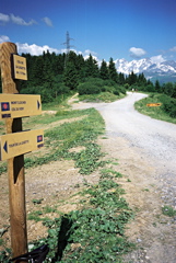
The best views are on south climb in the higher regions toward the Mont Blanc region. Col des Saisies/Les Saisies is a big, touristy ski resort village. Mont Bisanne (Signal de Bisanne) (1941m) is the highest and most interesting asphalted climb in the area. To go to Mont Bisanne from the Saisies you go down to 1575m on the south side and take a road up there where you have very good views. Photo here is from Col de la Légette.
Some more approaches I accounted for earlier: 1227m - 17 km (Villard-sur-Doron); 1267m - 17.9 km (Les Perrières via Doron); 1287m - 17.7 km (Les Perrières); 1415m - 20.7 km (Queige); 1589m - 24.9 km (Ugine (south)); 1561m - 23.7 km (Ugine (east)).
[FR-73-1786]