homeJouf de Ciareja/Karerpass/Passo di Costalunga/Pas de Costalongia
Jouf de Ciareja/Karerpass/Passo di Costalunga/Pas de Costalongia Height Climbing height - length
1752m (road height 1755m)
433m - 9.6 km (S. Giovanni/Sèn Jan new road)
431m - 9.7 km (S. Giovanni/Sèn Jan old road)
450m - 9.7 km (Pozza di Fassa/Poza)
876m - 13.8 km (Birchabruck/Ponte Nova)
1466m - 25.48 km (Kardaun/Cardano)
Difficulty Beauty
West 3-4 (5); East 2-3 (5) 3 (5)
How to get there

In Val di Fassa to the east one starts the climb in San Giovanni/Sèn Jan (1322m (new road first from the south) or 1324m (old road)). Coming from the north down the Val di Fassa one starts in Pozza di Fassa/Poza (1305m). (Further south in or after Soraga (1210m) there are some gravel road alternatives, but probably they are too bad and/or steep with a road bike.)

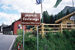
From the west via Nigerpass/Passo Nigra (1685m) one starts just below the pass at 1704m. The longest and hardest climb and probably (have not done it from that side yet) most rewarding starts to the east down at Birchabruck/Ponte Nova (876m) or quite possibly all the way down from Kardaun/Cardano (286m) and climb via the nice Eggental/Val d’Ega and Karersee to the pass.

Other comments There are a few flat kilometres just east of the pass. At the pass there are restaurants. The road up from Bolzano through Val d’Ega/Eggental was very nice with its gorge, but now the old road is closed and one has to go mostly through tunnels (but possibly the old road might open to cyclists again). (See the Virtual Alps web page.) (Pas de Costalongia and Pas de Mont are Ladin variant names for the pass. Passo Carezza is an Italian variant name.) See also: Reiterjoch/Passo di Pampeago (1996m); Passo di Lavazè/Lavazè Joch/Passo de Lavazzé (1807m) and Passo di Oclini/Joch Grimm/Jochgrimm (1990m).
[IT-TN-1745]
Map