1171m - 18.58 km - 6.3% (19.40 km) (Carano bivio San Lugano to Zischgalm)
1338m - 17.44 km - 7.7% (18.26 km) (Cavalèse SP232 to Zischgalm)
1017m - 10.47 km - 9.7% (11.31 km) (Tésero to Zischgalm)
1104m - 11.50 km - 9.7% (12.34 km) (Lago di Tésero to Zischgalm)
716m - 7.53 km - 9.6% (Rauth/Novale)
866m - 9.34 km - 9.3% (bivio Weissenstein/Pietralba)
1120m - 11.51 km - 9.8% (Birchabruck/Ponte Nova)
1730m - 23.19 km - 7.5% (Kardaun/Cardano)
2226m - 36.44 km - 6.1% (Egna to Zischgalm)
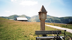
From the south, the most natural (and most famous) climb starts in Tésero (987m) (or lower down near Lago di Tésero (900m)), which is a very hard climb. The other south variants are about as hard or tougher still. From the south you can start in Molina (809m) and go via Carano (1007m). You can go through Cavalèse too and I show the hardest variant here. Both described roads has a no traffic sign at one section, but usually that is mostly meant for cars, I think. Then you cross over the Passo di Pramadícco (1443m (1451m)) to Stava (1278m) and climb up to the pass. If coming from Passo di San Lugano (1100m), you would do well to take the road via Carano and over the Passo di Pramadícco and up from Stava. The road from Stava is quite steep and often above 10%. At the Alpe di Pampeago (1757m) the road has been asphalted since the visit of the Giro d’Italia in 2012 and it is now the only +2000m fully asphalted pass in the Dolomites that is close to traffic except for locals and cyclists. Just after the road height at Zischgalm (2004m) the road descends a little to the actual pass and this part was asphalted since earlier days.
The northern climb could be started already down in Kardaun/Cardano (286m), and thus it becomes a very hard and long climb. You would climb the famous Eggental/Val d’Ega road. This has long new tunnels at the start, but it might eventually be possible to use the previously unusable old road that is very nice in this part. One would do well to make the climb over Karneid/Carnedo to bypass the tunnels on the valley road, but it involves a lot more climbing. The road is very narrow on the last section on the north side from Obereggen/S. Floriano (1512m). A nice alternative is to take the road over Obergummer, but it is a little more obvious choice if heading for Jouf de Ciareja/Karerpass/Passo di Costalunga/Pas de Costalongia (1752m), so I include it there instead.
If coming down from the Karerpass or Nigerpass/Passo Nigra (1685m) one starts at Birchabruck/Ponte Nova (876m). If coming down from Passo di Lavazè/Lavazè Joch/Passo de Lavazzé (1807m) one starts at Rauth/Novale (1280m). Finally, if coming from Ora/Auer (247m) over Aldein/Aldino and Deutschnofen/Nova Ponente, you will start a bit down below Rauth/Novale at turn-off (1130m) for Weissenstein/Pietralba (1520m) and these villages. Also including the hardest possible climb from Egna/Neumarkt via Truden/Tròdena, which is 6.1% even including three downhill sections (at one point up to Gleno/Glen it is ca. 30% and I think anyone with a road will have to walk the hardest ramp up there).
[IT-BZ-1990]