1392m - 21.5 km (Bourg d’Oisans via Alpe d’Huez)
1373m - 22 km (Bourg d’Oisans via Col du Cluy)
1291m - 26.4 km (Bourg d’Oisans via Lac du Chambon)
1480m - 28.80 km (Rochetaillée via Villard-Reculas)
1419m - 25.88 km (Bge du Verney via Villard-Reculas)
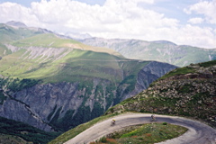
The classic Alpe d’Huez climb is part of the western approach to this pass. One could do the full Alpe d’Huez climb from Le Bourg d’Oisans (717m) or one could come down from the Col de la Croix de Fer (2065m) road and take off at the southern side of the dam Barrage du Verney (772m), and climb via Villard-Reculas and Huez (1480m) to the pass. The eastern climb starts by the big dam, Barrage du Chambon (1040m), on the Col du Lautaret (2057m) road.
All the approaches are steep, but the easiest is the one from Bge du Verney, where the road is almost flat for some kilometres between Villard-Reculas and Huez (1480m). This is probably also the most beautiful way to go to the pass. The road goes descends a little between Alpe d’Huez and the pass. There are several rough water drainage passages (cobblestoned depressions in the road) on both sides of the pass. You can also climb from Bourg d’Oisans via the gravel road pass Col du Cluy (1801m) with 6.7 km of gravel road that should be mostly fine.
[FR-38-1999]