Now it was time to go away on my little 6-day trip around Colorado. I wanted if possible to get all the way up to the famous Trail Ridge road between Granby and Estes Park, which is basically in the opposite (diagonally) corner of the Colorado mountains to the Telluride area. Thus, I decided to start by taking the earliest taxi van (Telluride Express) to Montrose in the morning. The nice taxi driver dropped me off at a suitable hotel on Main Street to book a night for the return and a place to leave my big bicycle box at. I had obtained two good books while planning the trip at home: Passes of Colorado: An Encyclopedia of Watershed Divides by Ed Helmuth and Gloria Helmuth & Road Biking Colorado: The Statewide Guide by Michael Seeberg. I read the first lexicon from beginning to end and most of Michael Seeberg’s very nice book, which is really helpful for planning a road bike tour through the Colorado mountains. (I just wonder what he means that the places offers the “basics” as if everyone knew what that includes and sometimes the language is a bit repetitive, just like me I guess … .) A simple map like GTR mapping’s ‘Topographic Recreational Map of Colorado’ for $3.95 is probably all you need for road biking in Colorado. You can buy more detailed maps when you are there, if needed.
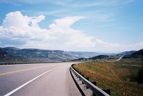
After booking the room and filling my water bottle I was off in the heat – it can be very hot in Montrose! Thankfully I was enthusiastic at the start and thus stayed in good spirit until I reached cooler places. One first climb a little pass, called Cerro Summit (2452m). Montrose is at 1770m height above the sea and is thus very low--laying in relation to the mountain regions around. Then there was a bit more fun climbing up to the Blue Mesa Summit (2614m) after a descent to the Cimarron valley. On a short section here was my first (out of perhaps only two) encounters with truck drivers who was not too happy about sharing the road with me (a bit like some bus drivers at home, I guess) – it was on the only really narrow place on the whole highway. This was no big problem and then I had a nice descent to the Blue Mesa Reservoir/Lakes, where I had the first photo.
I got a bit tired before I eventually reached Gunnison, where I had lunch at an Italian place. They had some good sandwiches and coffee. I drank a lot of water also. It is difficult to find water along the way on roads in Colorado and I filled my water bottle here. I started out again on the busy road toward Crested Butte, but turned off for Almont after a while. I had bought three postcards in Telluride, but should have bought four. I bought stamps for four at the post office right out in the woods here after Almont and discussed the road over the Cottonwood pass a little to make sure I was not in for any unpleasant surprise later.
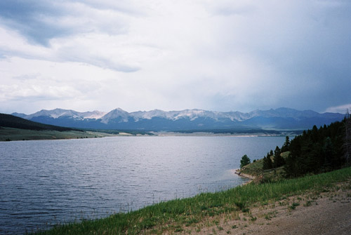
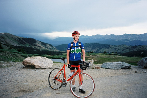
It was a long road up to the Taylor Reservoir – all distances seemed long here in Colorado, both since I am used to kilometres and not miles, and since the altitude takes its toll almost unnoticeable. There were quite some traffic even on this slightly rough small road. There are many people hiking, camping, mountain biking, fishing, and so on in this area and there were plenty of campsites along the road. When I reached the Taylor Reservoir I had very nice views of the mountains around the lake. (2nd photo.)
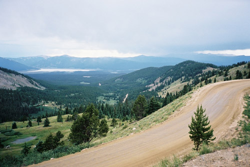
I had to cycle around the reservoir to the other side before I found the right turn-off for Cottonwood Pass and Buena Vista. It was marked with a sign. Here the gravel starts right away. The road is unpaved for 14 miles (22.5 km) and the road climbs constantly but is never steep. There were perhaps some shorter steeper parts close to the end, but nothing that was difficult in any way. It was difficult in another way, though – even though the road is good and wide generally speaking, it was also like a washboard most of the time, which destroyed most of the pleasure cycling up here. There are not so many views here either until you reach the upper parts. The top is really very nice with grand views in all directions. From the top it is also a good asphalted road down to Buena Vista. The road is a little steeper on the paved side.
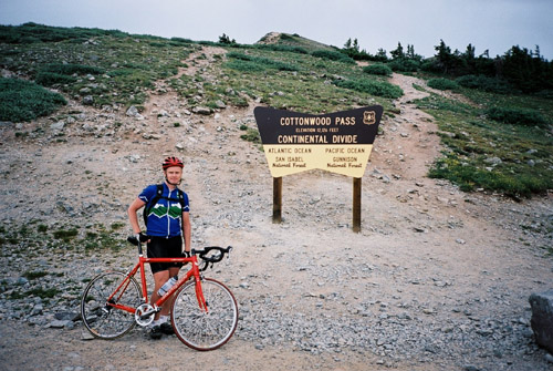
Cottonwood Pass (3696m) is one of the highest paved passes in Colorado and you notice the height for sure. I met two people at the top who I was asking of possible places to stay for the night. Initially I had hoped to possibly get further than Buena Vista, but since it is far between places in Colorado, I decided it would probably be enough to get down to Buena Vista. It took some time even though I had good speed to get down to town. I got a room at one of the first places I saw and went and had a huge American pizza and drank a 2 litre Coca-Cola Light – no problem to avoid going around hungry in the US (unless you get caught out in the wilderness, that is)! ;-)
