Okay, this day was clearly the most demanding during the trip, with approximately 50% unpaved road. I am far from sure I could repeat this.
I was damned lucky to have an almost perfect weather for the day. I went up at normal time (I should really have gotten up an hour earlier or two in hindsight). Today I was also lucky that I could leave my back-pack at the hotel, since I would have to come back the same way (well, unless I did not wish to carry my bicycle over difficult paths in the high mountains). That was a relief and perhaps that is what allowed me to succeed in reaching the top of Col Sommeiller (2993 m) (some claim it is slightly over 3000 meters).
The road up to Rochemolles is very nice in all ways and I can recommend you go up there even if you are not prepared to go all the way to Rifugio Ambin (at Col Sommeiller). I passed by two nuns walking up there, and I passed them by again walking down when I was cycling back down. There was also other people walking there and a few cars going to Rifugio Scarfiotti (2156 m).
There were also some people on motorcycles (germans, of course). The surfaced road continues only for a hundred meters after Rochemolles and the last 20-21 kilometers are then gravel road. At first it was steep and not very good, but when you reach up to the Lago di Rochemolles, the gravel road is almost flat and quite good for the most part and practically all the way to the Rifugio Scarfiotti. The road get steep again just at the rifugio, and here a section of very, very bad hairpinned road begins, that eventually could take you up to another plateau. At some places up the hairpins here I said to myself something like ”so help me God!”, because at some places there were no evidence available to support the idea that passage on a road bicycle was possible. There were big and smaller stones and water and mud and it was narrow with deep tracks after jeeps and motorcycles and it was steep. Ideally it should have been a bit drier.

I only put down my feet briefly at one point because I wondered about a sign and a road leaving off that I had not seen on any map. However, I never had to put down my feet on the whole way up and that is what counts according to me. The road actually goes down a bit at one place not so far from the top. Just here they were working on the road – but it was not clear to me whether their work really helped improving the road from my point of view. It merely added a new problem with sections of deep and loose gravel. It was in this area (around 4 km from the top) that there was a 100 meters or so of asphalted road (nothing recent though – maybe the only remainder of the road from the time when they had a ski station at the top and lots of tourists a few decades ago).
Just thereafter the last section to the top started and it was the worst. It was that sort of gravel road that is difficult to walk on. Almost only stones and water and some ice. At one place I had to choose to balance on a 10-15 centimeter wide and two meters long section of ice, but it was rather dirty so I got a grip. I was amazed over and over every time I managed to pass some bigger stones that did not look like I would make it. ”Now my luck will end” I thought several times on the way up, but there was no end to my luck this day ;-)!
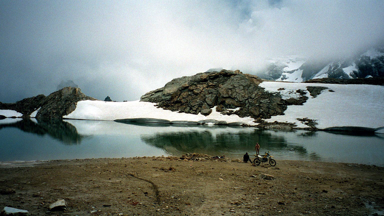
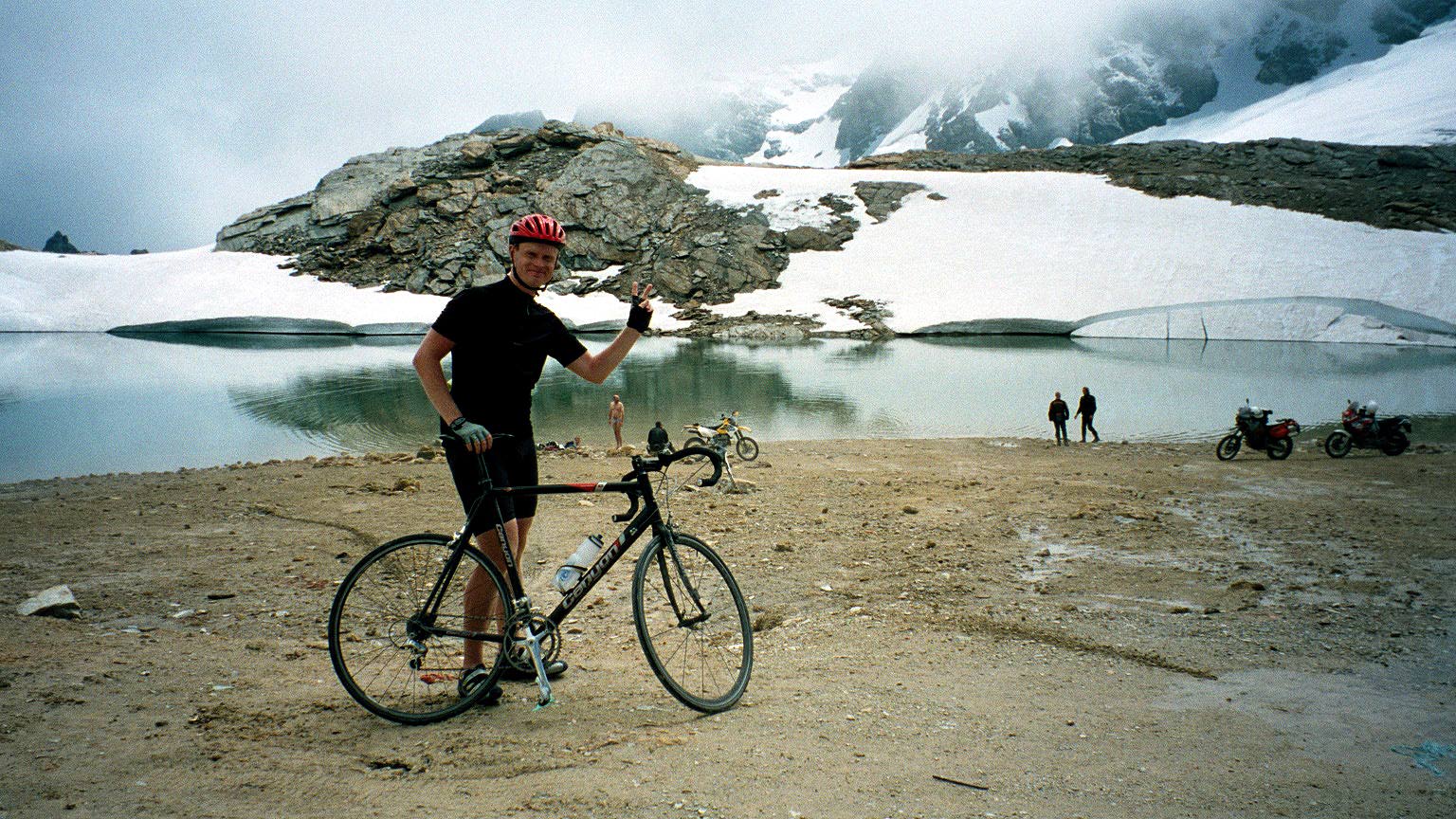
At the Col Sommeiller there were a crazy german taking a bath in the lake by the glacier. In the first photo you can see him coming up from the water. Then I had another of the germans motorcyclist take the photo of me. I asked him what speed he held up the road and he said around 60 km/h (I did not think they moved quite that fast past me, but maybe). And he asked me what speed I had imagined to have down the road! –Which off course left me without a good answer, but I estimated it would be around 12 km/h on average for the 27 km down to Bardonècchia.
Then I tried to cycle up to the Col Sommeiller Est (3000 m), but if I had only lifted my eyes a bit more I would have figured out pretty soon that the luck would have to end there as it did when the road was effectively blocked by bigger stones and I fell of the cycle and went up over snow to the col to have the third photo taken by myself of myself (behind my head the valley goes down on the other side). It was odd because it was around 20 celcius up here and sunshine. On the way down over the snow I met a guy who was out jogging and was running past me further up in the mountain – I asked him if perhaps he lived somewhere up there!
The way down to Bardonècchia was of course not much easier and I lost balance several times, but only had to put down my feet once, which is pretty good I think. I stopped to talk with some men invloved with the work on the road as one of them apparently wanted to talk with me. It turned out that he was the organizer for a yearly mountainbike event up this road. I asked him when he last had seen someone with a race bicycle up there and he said it must have been at least twenty years ago when the road was in much better condition and it was even popular to go up there then with road bike bicycles. I got a flyer for his event and promised to get back to him and send a photo. I did and maybe you could still find the photo over at his site (now removed): Stella Alpina MTB. This whole area of Piemonte is really perfect territory for good MTB rides (as far as I can gather).

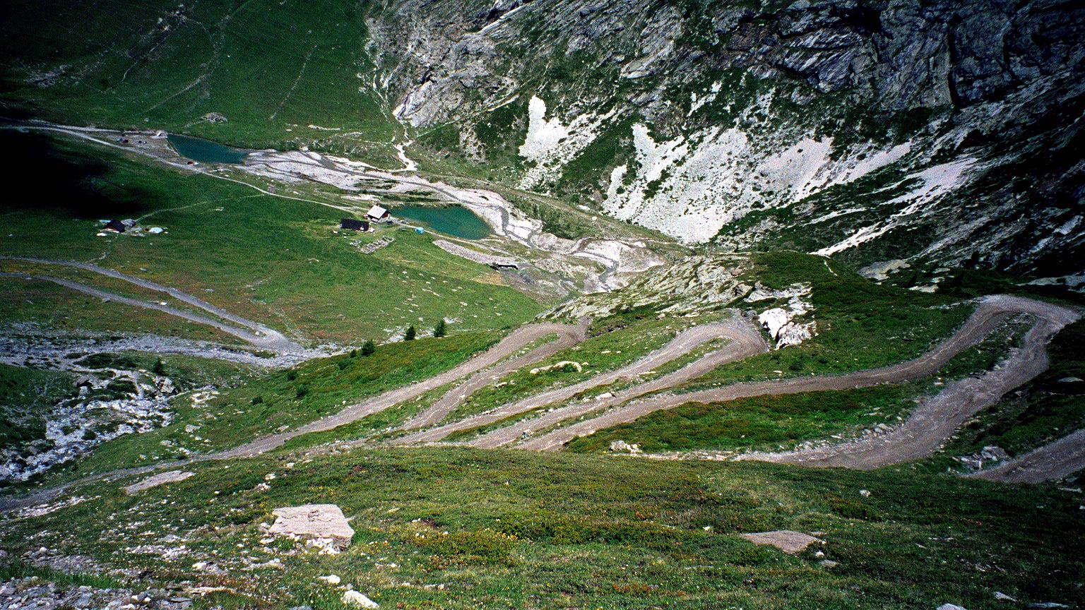
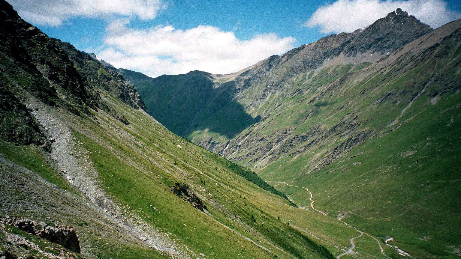
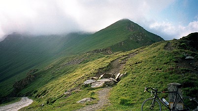
It took three hours to the Col Sommeiller and ”only” two and a half down to Bardonècchia. After all I wanted to continue cycling and could thus not dare to go much faster down, which also says something about the quality of the road. The photo of the hairpins is the ones above Rifugio Scarfiotti and the wonderful panoramic photo down the valley is taken from the same point. The last photo from this valley is taken between the Lago di Rochmolles and the Rifugio Scarfiotti. Why is it that the most wonderful valleys are also the most difficult to access by a road bike bicycle?
I left my money and all down at the Hotel Sommeiller, but all was still there thankfully. I did not stay for more than five minutes before I started to wheel down to Susa. I was still in a very good mood, but became a little less so as I approached Susa (502 m) as it was very hot down there. I went into a shop and got some bread, salami, soda and fruits (almost as usual), which I ate just outside the shop. It is really very easy to get what you want in Italian shops and they are usually more helpful than in France.
Well, now the clock was around five in the afternoon already and I was merely half-way through the plan for today. Now, I went up the road to Colle delle Finestre (2176 m) and even though this does not seem like a really high pass, you have to consider that one starts at only 502 meters height. This pass is in fact one of the most difficult in the whole of the alps and was the second most difficult pass on my whole trip after the Col Sommeiller, and on the same day. It starts out with a road with inclination of up to 17-19%, and it gets a little less steep (around 10% steadily) when you get past the houses and onto the less good paved road that continues in a myriad of hairpins up to Colletto di Meana (1455 m). In fact I found it difficult to drink on the way up since there was no place where the road flattened out until the Colleto di Meana, where the paved road ended and a decent gravel road commenced.
The gravel road them turned more steep and less good until I eventually reached the Colle delle Finestre (2176 m) very tired. This is the second to last photo here.
Then I cycled down on a pretty bad unpaved road to meet with the famous Assietta road (unpaved all the way to Sestriere). I was not totally clear on whether I could possibly get to Sestriere on this road before the dark fell and I had asked a motorcyclist on his opinion, but he had not come that road himself and I really wanted to go there and did not want to consult my map. I thought that maybe I could possibly see enough to make it to Sestriere. I started out on the road and it was good at first, but it turned out to have some really very bad sections and it involved much more climbing than I had ever thought it would (approximately 900 m in fact).
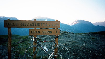
The photo at Colle dell’Assietta (2472 m) was the last for the day taken just when the sun had went down behind the mountains. I was happy to have reached also this col without having to set down my feet, which was not easily avoided here either. I did not had to put down my feet on the whole Assietta road in fact. This road is a ridge road that goes sometimes on one side of the mountains and sometimes on the other side. Thankfully it went a lot on the more lit up side towards the Susa valley. There were grandiose views all the time, but eventually it got dark. It was rather much up and down all the time on this road (not and long climbs or descents, but it was still a bit demanding). I tried to cycle as fast as possible to get as far as I could before it turned totally dark. The last col that I could read the sign of (there are many cols on this road!) was Colle del Lauson (2497 m). Then I passed other cols in the dark: Colle Blegier (2381 m); Colle di Costa Piana (2313 m); Colle Bourget (2299 m); Colle Bassett (2424 m); Colletto di Costa Treceira (2504 m).
Fortunately, I had a front light and it helped a little to avoid the worst obstacles. Just before reaching the last col I begun to wonder if I ever would reach Sestriere – the road was much longer than I had thought. I met a man in a Jeep and asked him and he told me I was practically soon there. I also had not remembered that the last col was laying so high. Anyway, I was soon trying to descend to Sestriere and it went fine despite a rather bad road and my missing to avoid some obstacles. I tried to look after shadows and so on the road surface. A funny thing then happened – I saw a big egg-like shape covering almost the whole road and got confused until I looked above me to see the wagon of the ski-lift hanging close above me! Actually the worst bump on the road was just when I was about to get out on the asphalt road, but nothing was damaged. In Sestriere it was cold and all looked closed and expensive and quite boring. So I just had to continue after a while down the valley on a road with speeding youngsters in cars who got a bit afraid when seeing me on the road.
I was eventually down in Cesana Torinese, but the two open hotels in town were fully booked and the third was totally closed and shut down for the night. Now, the clock was just minutes to midnight and I just could not go on to Col de Montgenevre as I had originally planned. One man at the little hotel in the center of the village (that looked the best for cyclists) mentioned a place run by a religious collective in the outskirts of the village, but I could not find it and had to ask at a pizzeria – the arrogant pizza man finally helped me understand the road to take (over the wooden bridge (where the pizzeria was) and up until the last road to the right and following this for some time until a bend where there is a little sign for the place (not something that helped you understand it was a place to stay for the night, but at the end of this short road there is a somewhat big house). The man inside was helpful and let me have a 7-bed room for 22 euro including breakfast. It was good. It turned out they had many groups of kids staying there involved in sporting activities. The place was very school-like.
I was tired.
Day1 – Day 2 – Day 3 – Day 4 – Day 5 – Day 6 – Day 7 – Day 8 – Day 9 – Day 10 – Day 11 – Day 12 – Day 13 – Day 14 – Day 15