A bit chilly in the morning, but it had dried up on the roads and I got warmer on the road up to the Pass Umbrail (2502m) (Switzerland highest surfaced pass and the highest border pass in Europe). I started out in a rather modest tempo, like I most usually do at mornings and after meals. This pass road is surfaced all but approximately three kilometres of good gravel road where there are easy gradients (2-3%). I have heard that they put tarmac on a bit more every year or whenever they can afford it down in Sta. Maria, so in the coming years this pass is likely to become a fully surfaced approach to the Stelvio pass.
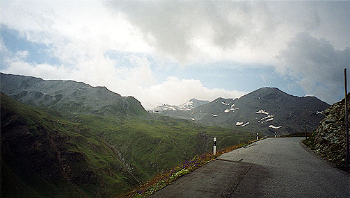
This valley is very much more quiet than the valleys in Italy on both sides of the Stelvio pass. It is also quite charming, but never more spectacular than what the first photo here suggests. It is the Stelvio pass that could be seen in the distance. A few serpentines after the photo I reached the Pass Umbrail and then the road hardly dips before joining the road up to the Stelvio pass. I got to do the last 10+ big serpentines on this side (never really very steep from Sta. Maria (up to 12%)). The side from Prato up to the Stelvio pass, that I did in year 2000, is the toughest approach and the most classic one with plenty of cyclists going up there every day. (That side is up to 16%, but usually around 9% – the real problem is the length though!)
After arriving at the Passo dello Stelvio/Stilfser Joch (2757m, the second highest surfaced pass in the Alps after Col de l’Iseran (2770m)) I met with quite different scene from in 2000, when I only saw one more cyclist on the whole way up and down and only 3-4 cars and none else. This time there were plenty of cyclists, cars and others up there and arriving all the time despite that the weather was not the best, but this was in the middle of the day and not at 9 pm (just when the sun went down in 2000). I had noticed on the map a small gravel road going of from the pass and in a book by George Rossini on the passes of Italy (ask me if you want to know more about this book) that there should be a pass along this road – Passo del Pratigliole (2908m) (a real pass I believe). This road leads to the summer skiing station of Pirovano at 3008 m height and was the highest point on my trip and of all trips to the alps thus far. I first took the wrong road (there is another small road going up higher among the houses at the top – avoid it as it does not lead up to Pirovano!). The gravel road is cyclable (R1 as the French Club des Cent Cols classify such roads) apart from two very steep (about 25-30%) and very bad ramps (cyclable in descent only with an mtb, I believe).
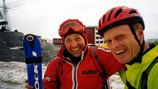
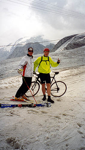
It just started to rain when the two photos of me standing where the skiers came down were taken. The snow was very slushy here and I could not walk around much there. I went back rather quickly again so I would not end up with mud all over the bicycle. At first I was not clear on whether I should get down to Prato right away or wait for the rain to pass. The surface of the road was not wet yet so I took a chance of possibly avoiding the rain. I got some rain in two long sections down there, but never really got wet and I was very happy rolling down those marvellous serpentines meeting hundreds of cyclists all going up meeting heavier rain, while I was ultimately escaping it (I guess I was singing on ’Singing in the rain’ a bit and could not help to smile at people going up. Wicked me!)
At Prato, I turned left on a straight and flat road going to the little medieval town of Glorenza/Glurns (908m) with an intact old fort-like look. I had initially planned to try and find a place there to sleep one night. Now the weather was fine again and after refilling my water bottle I went up the main road on the long, huge serpentines (or rather the road goes from one side of the valley and back again over this sloping farmland (one could get a bit problem with understanding the perspectives with the uniformly sloping plane)) with very moderate and steady gradient of around 4-5% (I guess). There are some alternative road choices that might have been more fun.
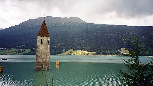
The two lakes at the top of the pass are quite nice. One could go on the other side of the Reschensee also and that is also something I had originally thought of doing, but it was nice enough for me on the fast and easy side (although with many cars). I had a little lunch near the pass at Reschen. I took a photo of the famous church buried in the lake apart from the tower after the Reschensee got dammed up and most the town of Reschen got buried in the lake.
I did not exactly get a warm welcome to Austria. When I came over to Nauders in Austria I had take shelter against a thunderstorm and heavy rain. Then I continued in the rain down toward Landeck and I did not start to get a bit dry and warm before arriving at Landeck (817m). It is very nice scenery for a while after Nauders and a very dramatic landscape (quite unlike the rest of both sides of the Reschenpass). I managed to find a decent pizzeria/restaurant in Landeck (by going in the right direction after the centre). Now the time was around 18 and I was not much in the mood of cycling, but got on my way toward the valley (Paznauntal) leading up to Ischgl, Galtür and the Bielerhöhe pass, which is one of the few surfaced passes above 2000 meter in Austria.
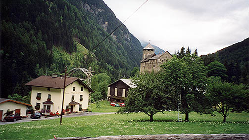
I had found a route via an odd source – Microsoft Autoroute 2002. It was there evident that it would be quite possible to take a road going over Perfuchsberg and Tobadill (1138m) to See in Paznauntal. This turned out, after a bleak start from a road going left soon after leaving Landeck in the direction of Pians, to be a really good choice. The last part from Tobadill down to Paznauntal was very nice on a narrow but perfect tarmac road. You see a small castle near the Trisannabrücke, where you join the road up the valley (see photo).
The road to the Bielerhöhe from this side must be one of the most easy climbs up to a +2000 meter pass in the Alps. It is only more steep than 4-5% at two short stretches (esp. near the end) and there it is at most around 10%. I cycled on not hoping to get to Bielerhöhe this day (it was cloudy anyway) and looked out for possible good places to stop for the night. I could not quite decide and almost every place looked extremely well-prepared for tourists and all looked rather expensive. Arriving at Ischgl, being the top disappointment in this regard, I never even thought of looking for a place there. So, I turned out going all the way to Galtür (1584m). I thought about perhaps going to the Bielerhöhe even after I found a good place for the night there, but it was too cloudy, cold and beginning to get dark.
Day1 – Day 2 – Day 3 – Day 4 – Day 5 – Day 6 – Day 7 – Day 8 – Day 9 – Day 10 – Day 11 – Day 12 – Day 13 – Day 14 – Day 15 – Day 16