I was away around the same time as usual in the morning (9 am) and went first to Cavalese, which is really a little town. I had a soda and after a little confusion found the proper way out of town up the road toward Passo di Lavazè. This road is sometimes steep, but mostly it is varied and nice. Somewhere above half-way up, there is a road leading over to an almost parallel road going up to the Alpe di Pampeago.
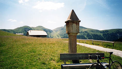
The road up to Alpe di Pampeago is quite steep and is often at around 14%. I guess it is over 10% on average from where you get on this road (above Stava) by the way I took over the Passo di Pramadicco (a rather level road). At the Alpe di Pampeago, contrary to this year’s participants in the Giro d’Italia, I continued on the fine gravel road up to the Passo delle Pampeago. There is even a bit asphalt on the perhaps 3 km up there and at the top it is surfaced all the way down the other side (though the road there is very narrow, with drainage gullies, and rather steep). You see the top of the pass in the first photo here. In the distance you can see another gravel road taking off from the gravel road up here to another pass (Passo Feudo/Satteljoch (2121m) or maybe it is south of this). I believe that road was not supposed to be cyclable, but it may very well be (slightly steeper there though, I would guess) – I regret a bit that I did not get up there.
Then I came down to Obereggen, which is really another pass on the road down there. This is a tourist village with many hotels, but with a nice view back up the valley I descended. I winked at some people in the lift crossing the road higher up just above ones head. A wide and very smooth road took me further down to Novale Rauth (ca. 1300m) in the Obereggental. Here an evenly steep climb back toward Passo di Lavazè, that I had climbed far up on the other side begun. Around 8-9% on average, I believe. At the top there is a surfaced almost level side road going to Passo di Oclini/Grimm Joch (1989 or 2000 m at it says on a house there). I think the road may touch the 2000 m mark, but I am not sure.
At the highest point there are a few buildings (a few nice older ones also). There are lovely views in almost any direction from this pass and you can see far in many directions, which is not so usual on many road passes in the Dolomites. The Lavazè pass is really dull, so if you go up there, you should definitely proceed to this pass. You can either go back down or continue on a gravel road which is level and nice for a while until a farm, where a really dusty and somewhat harsh (but it is still no real problem with a road bike apart from constant use of the brakes that makes you hands ache and getting your cycle dirty). I was lucky to get off this dusty road just before a really big timber lorry went up full speed there – if I had been on my way down then I would probably have had to go to the nearest lake and take a bath. There is much logging activity in this area (and many forest roads)!
The road down from Radein (the place just above where you reach tarmac after coming down the Oclini pass) is very, very quite and very good.
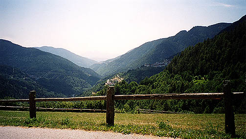
The bigger road coming up from the valley between Trento and Bolzano is of course rather busy and with easy gradients. At the top of this road lies the small village San Lugano and just afterwards you can take off to the right to make a short-cut into the Val di Cembra. This very nice and very recommended road at first climbs a few hundred meters, but only very gradually. It is nice and good at first, but nothing special. At Altrei, however, you find this very nice and peculiar little village. I did not remember my map here and usually do not look on it unless I know I am not sure anyway. Apparently I could have taken right on entering the village and went on to Capriana on a slightly sloping road and from there went down to the main road on the right side of the Val di Cembra. However, I went straight through the village and found a little church at the end and wondered slightly confused if I should try the tiny (extremely narrow) road going left around the church (looked more like a cobblestoned walking path). I looked a bit around and guessed it could not be totally wrong. Soon after the church it is tarmac again, but almost always as narrow (do not go fast down this road!). I took the only photo in this valley on this narrow road. It leads down to Carbonare and there one could chose to continue to Capriana or go down to the main road, and I did the later (though Capriana looked nice from here, it is the village you see below in the photo).
The main road down the valley is somewhat nice. I cannot tell if the road on the other side is nicer or not, but I believe the right side might be nicest. Further down the valley I went over to the left side (practically the only place to cross the valley). The road goes steeply to the river and then up steeply on the other side. I went via the Passo di Lasès and down to Trento via some high small road just above the town (had to climb up a little at first there).
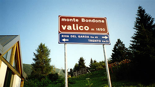
I bought a new tube in Trento (small cycle shop) and had some good sandwiches. At around 18 p.m. I got across the river on a very big road (there is apparently a smaller road, but I could not find where it began) and eventually found the road going off to Monte Bondone (I was slightly afraid I would miss it, but it is basically the first place you could get off the road). It is a very nicely hairpinned road all the way to the top. It was quite hot at start at Trento (194m) and it was totally impossibly to get a clear picture of how far it was to the top. It seemed like I did not get anyway for quite some time. I remember reaching the little village at 1000 meters height (there were some signs showing on which heights one would find different villages). I thought I was close to the top then, but got slightly depressed to find out I was only half-way up there. However, when you reach the last little village before the top called ’Norge’ after the country next to where I live (Norway in English) – then it seemed like it was still quite a bit to go, but that was not true as it is very soon thereafter that you reach the highest point of the tarmacced road, the Valico di Monte Bondone (1654m). However, there is a small steep gravel road going up to the top of the mountain.
From there an almost flat road goes around the mountain and then I went right and right again over some pass again. Thereafter down the valley on long serpentines where one could wheel down at around 60 km/h all the time without either pedalling or using the brakes, almost no braking needed in the wide curves either. You finally come down to farmland at Lasino (463m). There it is best to go left toward Lago di Garda via the Passo di San Uldarico (584m) – only noticeable as a pass since the road beyond it starts to go down very fast again. Just where it gets steep down to the low valley side above Lago di Garda, I stopped at a small village called Drena for the night. A reasonable choice with a decent view over the valley below. (It is a pizzeria/hotel at the start of the village from where I came.)
Day1 – Day 2 – Day 3 – Day 4 – Day 5 – Day 6 – Day 7 – Day 8 – Day 9 – Day 10 – Day 11 – Day 12 – Day 13 – Day 14 – Day 15 – Day 16