Yet another rainy and quite cold day. I was almost wondering if I should give up because of the weather at the end of this day, but luckily it started to get better again (for a while) the next day. I had no rain at start and I think the road was dry up to Pass Thurn (1274m), which is a very easy climb on this side (and also somewhat easy on the south side, but nicer there). As the weather did not look good where I was going this day, I merely had on my agenda to do what was not to be left out no matter what of my plan. Thus I started out directly across the valley as I came down to Mittersill to climb up the Felbertauern road.
I stayed on the main road through Mittersill, but believe that for a short stretch one is not supposed to use a bicycle here, for some silly reason as you directly thereafter join the same road you had just before shared with all the traffic and the only difference here is that the road has more room to accommodate bicyclists and is straight (maybe I was allowed to bicycle here, not sure).
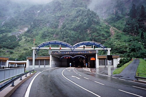
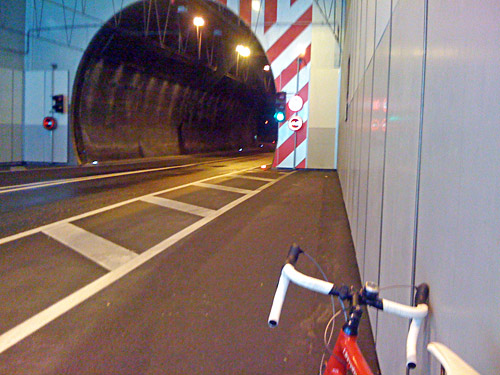
This road is not so fun to climb for cyclists (and I think the Felbertauern tunnel operators suggest it is not really suited to cyclists on their website). Apart from being a partly boring climb, there is no big reason not to go with a bicycle up here. Some drivers may wonder why you are there and where you are going, but the road is mostly wide. One is not allowed to bicycle through the tunnel even if it has been opened for certain bicycle races. Austrians are keen on regulating things, but long tunnels like this are often off limits to to bicyclists everywhere for alleged security reasons. I think the worst is the bad air inside the tunnels and heavy traffic.

It is possible to call for a shuttle service to take you through during certain times of the day though so you can continue on the other side cycling down toward Italy and this day it would have made a lot of sense to do just that, but that was not my plan, hmm. The reason I went up here was to visit this tunnel-pass as it happens to be one of those passes above 1600m that are asphalted. I had originally planned to go up the south side as it is supposed to be slightly higher there, but as it is above 1600m on both sides and the north side is actually the most demanding side to climb, I thought I could as well climb it from the north. That way I could make sense of going back and over the Grossglockner road again.
It started to rain a little as I got higher up, but there are many tunnel-galleries on the way up so I did not get wet. It rained most just at the entrance of the tunnel, where I stopped a bit frozen for a photo and a rather short stop as I had to go down before I lost all warmth in my body. The Felbertauern (tunnel) is 1607m on the north side and 1632m on the south side. Apparently the highest point is in the middle of the tunnel at 1650m (which is a bit unusual for a tunnel like this, as they usually slopes from one side to the other). So you cannot quite reach the point on a bicycle here, but for all purposes you have reach the pass at either side of the tunnel as the slope inside is hardly even visible.

I got down again and followed the main busy and somewhat narrow road to Fürth, where I took off to Kaprun as I had hoped to find a bicycle path over to the Grossglockner road there, but never found it, so had to return back again after having a coffee and apfelstrudel at a café in the slightly boring Kaprun. Now it started to rain heavily again and I stopped to take shelter for a while at a bus stop. Then continued on the main road and turned off on the Grossglockner road. After a short while I had to stop again to take shelter before getting totally soaked.
A russian man came on a bicycle asking me if he was on the right road to Grossglockner, which I could not deny. I later passed him by after Fusch (813m) again. It never stopped raining totally more than during short passages on the way up the Grossglockner. I met a small group of cyclists coming down above the where the toll road starts and where the weather was a little bit better for a while. Just before the toll road starts a couple had drove up with their car and starting out on the bicycles apparently hoping the weather would get better, but it would not. The advantage of climbing popular roads like this at odd times of the day or in bad weather is that you get an amazing road very much to yourself (and it seems like I have been successful in this regard on all my three visits here thus far).
The rain stopped eventually when I got higher up and I hoped that it would not come back again, but it soon did as I got up the Hexenküche serpentines at around 2000m height and where it starts to feel that the road is a bit steep and long. (Many of the bends in the serpentines have names with altitudes given.) The Grossglockner road was built as a tourist attraction in the 1930’s and therefore offer great views most of the time. Now it also started to get really cold, but I kept going in a steady speed and I was certain that I would get over and down the other side this day somehow.

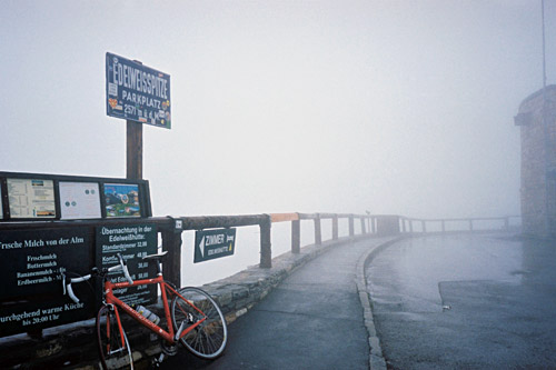
Now, the real reason for wanting to climb this road yet another time (besides that it is a nice and helpful route), was that I never managed to get up to the highest point at Edelweissspitze (2572m) above the Fuscher-Törl (2406m). I feared that this road might not be possible this day either as it might well have fallen snow up there this day. When I first visited the road this part was closed as there had been massive snow falls just before and the second time it got dark by the time I got up here, so I did not see the point of going up there in the dark). It was only 5 degrees with rain that was frozen that kept pouring down on me, but I anyway decided to give it a try and went up the partly cobblestoned steep road to Edelweissspitze (2572m). I was hoping the sky would open up by some miracle so I could get a glimpse of the nice views from up there, but even if the cloud cover was very thin up there, the sun did not manage to break through.
I just put my bicycle by the sign took a photo and decided I need a cup of tea and I saw the hütte up here was open, so walked down and ordered a camomile tea and apfelstrudel and sat down. They only had one other visitor – a Danish motorcycle guy with his daughter, who happened to have a friend (or his brother) in Gothenburg, near where I live. We talked a little and he also thought it was cold, which I thought sounded silly given all his clothes and gears. The girl wanted to join her brother down in Venice where it should be 27 degrees right then. The owner (?) gave me a book showing me how it could look up there in good weather and told me the cloud cover had opened once or twice during the day for maybe 15 minutes or so.
Eventually I stepped back up to jump on my cold bicycle down the the road in just the same weather as I had arrived in. Not totally dry I was as cold as before when I came back to the Fuscher-Törl (2406m), but it was okay with the first stretch up to the parking place by the Törlkopf (2428m), then it was nasty down to Fuscher Lacke (2262m) and up through Mittertörl (tunnel) (ca. 2327m), which is also a little non-obvious pass (at least it there is a little pass above the tunnel), but the one through the tunnel is not much of a pass itself and only counted because it is regarded as a pass by some, the same goes for Kasereck (1905m) on the south side.
The climbing up to the Hochtor (tunnel) (2504m), was welcome as I would not get much colder during that passage, but the temperature probably dropped to the lowest here at 3 degrees (maybe it was the same at Edelweissspitze). Luckily the rain stopped and the weather looked better on the south side with rather wide views, but I did not stop for any photo as I was simply too frozen (I think). Then came perhaps the worst part down from Hochtor. Even if it was no longer raining it was suddenly very windy and on some stretches down from here it was terribly cold and hard to get down simply. It will get better I told myself and when I came to the turn-off for the Franz-Josefs-Haus (2370m) (a stretch I still have not climbed here), it got more endurable. It is then slightly up to Kasereck (1905m), which is sort of a pass over a spur in the mountainside.
Then I pressed on to get down quickly to get a bit warmer again, but decided to take the small alternative road via Apriach which turns off at 1514m above Heiligenblut. I went in here and stopped for a last photo of the house one had to go through on the start of this road, but a stupid car driver came by and simply stopped there, so a hasty shaky photo only. It then turned out that the road had been blocked, but it was just to move the blocking and put it back to continue as I did. When reaching the other end another car driver had just stopped to do the same with the road block there and I passed by. (Never saw any obvious reason for the blocks, but the road is very narrow and maybe it needed repair or something.)
It started to get warmer again, but this road does not descend very fast. I think it was as I reached Apriach (1446m) (no very informative signs up here) that it started to rain again even though it looked earlier on like I would possibly escape any more rain. I guessed on some road choices, but I got on the right one (always took the one going down). When the road finally started to really descend rather quickly it started to rain very much and I soon got all soaked. I had previously hoped to possibly turn of this little road just before reaching Döllach (1013m) and climb up the Zirknitztal to Grosssee (2470m), but it was both too late and I was totally soaked, so there was zero chance I would even think about it now. Maybe the next day, but not likely and I quickly decided against it I did not want to get on a very cold place right away in the morning again, but rather move out of the area.
I stopped at a place in Döllach (1013m) where I got a room and access to a shared shower in a big house. It was fine (a bit special). Then I went out and got something to eat on a nearby pub/restaurant and managed to borrow an umbrella as it was just raining, raining, raining.
