
I started in the same way as I finished the day before – full speed ahead. Again, I do not know why, but first it went very fast up the main road (where you once again were not supposed to bicycle for some unknown/unintelligent reason). So I wanted to quickly get by that area to the part of the road where you were allowed to bicycle (the higher more narrow road with more traffic, of course …) from Pfunds. I was close to 30 km/h on average on the uphill out of Austria.
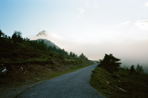
My memory of the maps had made me think that when reaching the Unter Engadin valley in Switzerland I would somehow have reached a valley floor where it would be relatively flat, but the road here is actually climbing much more than the road from Landeck to here. So eventually at my speed I got a bit tired. Especially after Scoul where there was heavy climbing, road work and more flies than anywhere on the planet and it was also getting a bit hot now! I had a nice photo along the main road of typical wonderful view when cycling through the Unter Engadin. In retrospect (not long after I realised this) that I should really have taken the smaller alternative roads to the main road as those would not have slowed me down much from what I could gather (I thought so while there, but then started to doubt it, too late). I would most likely have gotten much nicer views on these alternative routes and I saw some cyclists coming down/going up them. The first is via Sent (looks on the map that there could be a bit steepness at first here) and then via Ftan, Ardez and Guarda (which all should be nice villages too). The Michelin map indicates that part of the Ftan road should be unsurfaced, which is probably not true (the Michelin maps of Switzerland are very bad in regard to road quality and smaller roads in Switzerland) – I doubt the Michelin maps have been updated outside main road/main cities in Switzerland since around the second world war. Next time I will take that road.
At Susch the road is more narrow and there is a lot of traffic here. At Zernez (1464m) it was lunchtime, but not for me, I decided, so I simply went through despite starting to get both tired and hungry. The weather was perfect and I wanted to get far today as I had ideas on what I should be able to do at a minimum this day. So no stop until Livigno for me. I decided to go through the Livigno tunnel for the first time ever and I noticed some signs saying there was a bike shuttle up there every 30 minutes, so I tried to hurry on to catch the one at 13:00. Even though continuing going at high speed up to Ova Spin (1879m) I was passed by by a really good cyclist that I could not catch up with. I was also at the most tired right there and this chap probably started out fresh down in Zernez. Anyway I only arrived at the tunnel 5 minutes past the hour. I noticed a sign saying it was not allowed to bicycle through, but as there was no alternative road choice I thought it did not make sense and I had even heard that one could bicycle through here. I saw no oncoming traffic and the toll both people did not look my way, so I just went ahead, hoping I would get through or as long as possible before I would meet any traffic.
This 4 km long tunnel has a slope and is narrow! I was going in more or less exactly 22,5 km/h all the time, which seemed like a good speed and I could read markers along the way of how far it was to the next exit. If cars would have come down I could jump off the bicycle and walk on the side up there, but it was unlikely I could meet cars while cycling as it was so narrow, but it should not be a big problem letting cars pass by. I was very surprised and happy to reach the other side of the tunnel before any oncoming traffic arrived. It was a nice feeling cycling through here (like cycling deep down a mine and likewise not so good air …). There was traffic waiting to get down just as I arrived and in retrospect they might have had to wait because someone knew I was in the tunnel (I do not know).
I thought I had made it and the weather was nice and fine up on the other side too. I noticed another toll both just ahead and I was asked by a lady to show my passport. She did not look very happy and took some time getting back to me and then told me if I knew it was not allowed to go through the tunnel with a bicycle. I told her that I had just missed the bike shuttle and was busy and had no oncoming traffic, so there could not possibly be a problem. Well, all she had to offer was that “verboten ist verboten” and I had to pay a “fee” of 20 euro. The bike shuttle would have charged me 5 euro, so I only lost 15 euro, but I was still not happy with this. I wondered for myself if I had not arrived there during the few hours the bike shuttle was running (10-15 each day) – would I have had to wait until the next day to cross then?? I just read on another webpage that there had been an accident with a bicyclist in the tunnel two years ago, and that it was the reason for the new policy. So a bicyclist get into an accident and other bicyclists should have to pay for it?! – Bloody bastards! I guess it is all about getting money from tourists as the whole Livigno area is anyway. I have read somewhere that one could walk up the hillside and avoid the tunnel – maybe I will try that next time instead!
I think I soon thereafter met the bike shuttle as it honked at me – maybe thinking I cheated them on money, which made me a bit more happy. The ladies at the toll both also need some share of the pie, I guess ;-). There is supposedly a pass by this tunnel even though this is a bit unclear to me just how that is – Passo del Gallo (tunnel) (1693m). (Ova Spin (1879m) would seem a better candidate for a pass on the way here (from there it is downhill to the tunnel (1711m)). There is no point as low as 1693m on either side of the tunnel, so I am not sure what this is about. I see it is claimed as being of height 1809m according to the Cent Cols pass catalogue for Switzerland, so maybe another pass to include in my list then! This is the height at the Italian side of the tunnel.)
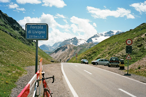
I was having lunch in the centre of Livigno at a somewhat bad place (had a lasagne). I bought a nice ice cream afterwards though and walked a bit through the streets until the ice cream was finished. Then I moved very slowly out of town. I noticed that I had gotten bit tired and it is always a bit difficult to start out in good speed after eating. Super-slow up to Fórcola di Livigno (2315m), where I have been twice before now. The road down on the other side was just as steep and busy with cars as always – I wonder when they will try and improve this horrendous part? I was back in Switzerland, but not for long.
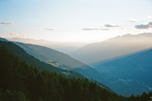
The very long descent to Tirano (457m) and Italy was once again fun and fast and maybe I had warmer weather this time than before. I stopped again in Tirano for a coke and cake. It was quite hot down here. I walked into a bicycle shop nearby, but found no cleat covers that I was looking for (odd thing here around, I believe). I was still a bit tired and somewhat reluctant about what was ahead, though I know it would probably be fun.
I was to get up to the (in)famous Passo del Mortirolo (1896m) or rather Pas de la/Passo della Foppa (1855m) with which it is confused. (Actually it is yet another ‘Passo del Mortirolo’ which it is really confused with, and which goes parallel on a grassy track to the Foppa pass (which I have not visited). Passo del Mortirolo (1896m) is near the Foppa pass on the road going west to Trivigno/Aprica on the ridge).)
The normal start of the Foppa/Mortirolo pass starts in Mazzo, but I had talked with another guy who had found yet another approach to the two normally known on this side (the other being up in Grosio). This starts slightly closer to Tirano in Tovo di Sant’Àgata (526m). I eventually got off the busy main road and was on a small road going between the small villages on the side of the valley up here. Then I came to Tovo di Sant’Àgata and went into the centre and found a sign describing several mountainbike routes up the mountain (rather interesting). I sort of guessed where the road up the mountain from here would go and thought I sensed the one to take, but got a bit unsure and asked a man in a car nearby (of course there was no signs here). He was pretty sure he knew what I was asking for and started to lead me over to Mazzo on a small road. Eventually it became totally clear to me that he had not understood that I was looking for another start than the well-known one. I stopped and waved with both my hands and finally I got him to stop (almost in Mazzo). He now understood, but was less clear about whether I understood what I was thinking of and what my choice would imply.
We went back and it was the road I was suspecting from the start – it looks like it possibly cannot go anywhere else than to a house and stop there. It is so tiny and unremarkable, that you would have to look long before you found a house with such a small access road. Oddly there we met a couple he knew who were apparently living up this road and they stopped to discuss whether it would be possible for me to get up to the Mortirolo this way. They decided that it was probably not possible, but that I could try it if I was prepared to walk some. They also warned me that it would be much more difficult than the Mazzo road. I knew that I had to turn off the road to get over to the upper part of the Foppa/Mortirolo road at some point and thought I would guess where, but as it turned out I never found any convincing place to turn off at – there were a couple of places where one could turn off at, but they all seemed to be going just to a house on the side. I later learned from my correspondent in Switzerland as he wrote: “There would have been a pointer sign saying “Murtaröl”; the road you continued on would still have been tarmacced, but the turn-off gravel.” I wished I had that information beforehand! The turn-off road would likely not have been very good either, but by continuing straight up walking was assured for some time!
The climb is actually a bit less steep than the Mazzo climb which is like 10,5% for 12,4 km according to the profile at salite.ch, but it has ramps that are steeper (I think up to around 23%, vs. 20% on the Mazzo climb). The Sant’Àgata climb is more wooded and I found the asphalt road more enjoyable here. After the extremely anonymous start the road turns quite good and climbs in beautiful hairpins up the side of the mountain with ever greater views. After much climbing and seeing newly laid asphalt I was starting to dream of finding a newly fully asphalted alternative climb to Mortirolo! Only dreaming … eventually I came to a gravel section (being wary that I might had missed the turn-off) I still continued. It was just about possible to climb up this gravel part and suddenly there was new asphalt on a perfect road again. This ended abruptly with a excavator machine standing in the road and then it was loose gravel where one would have to walk with any bicycle. It was looking like they were going to fix (asphalt?) more of the road here. I continued and could bicycle a little again on a gravel road, but it soon turned very bad and grassy and I was suspecting I had really missed the turn-off road long ago.
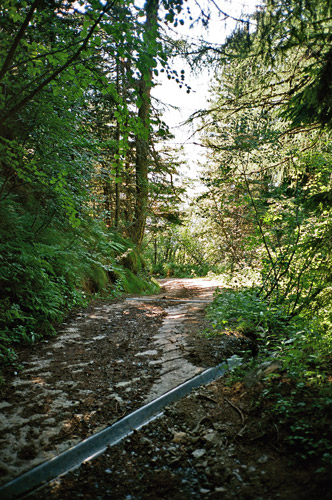
I decided to just take a chance and continue straight up as I had at least seen a path going straight up on the map and would thus sooner or later hit the Trivigno high ridge road. The track/gravel road above turned out to be curious as it shifted in quality greatly all the time, without apparent reasons. Obviously some people with houses up here had done some restoration work on parts of this road now and then and apparently most of it was regularly used with at least jeep like vehicles. However, there were a few sections that did not look passable with a normal car. It was almost always a bit too bad for bicycling and it turned out to be a road getting virtually straight up and it had some ridiculously steep ramps at up to 32% where I oddly found somewhat newly laid concrete pavement (see the photo from the steepest ramp with the new looking drainage gullies, which does not look steep, but I almost had to walk on all four up in that photo!).
Suddenly I took a big step and was putting my feet on the asphalt road up there! You see in the next photo the track I was coming up to the asphalt road. This took time!! It was now 19 in the evening and I still had one of the most important climbs ahead for my tour this year – namely one of the two +2000m passes that I had not previously climbed. I first had to go like 3 km over Passo del Mortirolo (1896m) to the Pas de la/Passo della Foppa (1855m) pass, from where a side road goes further east to the Col Carette di Val Bighera (2093m).
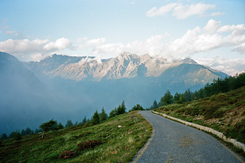
It was getting cold and clouds were starting to come in. Night was approaching. The lonely road to Col Carette di Val Bighera was a bit bad in some places, but is mostly quite fine. The road stops shortly after the highest point. I decided to not inspect the ending of the asphalt road s it was getting late. I had to hurry to get a photo before all surrounding mountains was out of view due to the fast raising clouds. You see in the 2 last photos before the last one (which was taken on the return along the Trivigno road) that I did not totally get the camera up in time, but at least the photo looking ahead at the pass was good, I think. I have heard that there is no road down this side, but I have studied the google maps satellite photos and they suggests at least two gravel roads or tracks down from here – there might be some walking involved, but I guess one could reasonable successfully get down the other side at least with a mountainbike.
On the chilly and somewhat long way back tand over and down to Aprica via Trivigno, I encountered a stretch of the road that was almost not cyclable due to landslides. I remember that the road was a bit bad from the Gran Fondo Marco Pantani race on this road that I took part in in 2006, but now it would have been very dangerous to have a race going here. Most likely the road has been cleared by now. Still the descent down to Aprica was still as dangerous as in 2006 and the wholes in the road has still not been fixed (only some paint to warn for them, which is of little help in such a race on the downhill). On the road one passes by Passo di Guspessa (1824m) (known by most), but also an obscure nearby pass called Passo del Picco (1870m). Trivigno itself is clearly a pass in all but name and I have decided to include this in my list already as ‘Conca/Valico di Trivigno (Monte Padrio)’ (1867m) (I have given the highest point of this road, not so far from the geographical pass below on the meadows). Not so long before the last part of the descent to Aprica there is a road (not any of the ones up around Trivigno) which is very easy to miss on the way down. This junction is marked as Passo S. Cristina (1400m) in the GF Marco Pantani and I think there might be other references too (it is anyway a clear pass distinct from the previously mentioned one). The Aprica itself is a pass – Passo di Aprica (1173m).
I arrived at Aprica just as it got dark and I think I bounced into something at the descent down there as it was hard to see the last part. I was staying at the Meublé Stelvio that I was staying at while at the Gran Fondo, but this place really is bad and I should have stayed elsewhere. They did not even have warm water when I was taking a shower (they fixed it so I got some hot water the next morning, but …). I had a pizza at a place that was open late (no problem with opening hours down in Italy thankfully).
