The day started with breakfast that the lady first wanted to serve outside, but as it started to thunder and came a little rain I sat in her kitchen instead. I was looking out the window hoping this would not be much and last long. Thankfully that was correct (at least for some time). So I left a little late (I think it was 10 sharp when I started out on the Mont Ventoux road). This was my first climb up this famous gigantic mountain so popular with cyclists everywhere. My idea was to start out easy and and focus on experience of climbing the mountain rather than rushing up. After a bend or two where the real climb starts, two danish guys came up to me from behind and I was content to raise the speed just a little to hang on to them and talk for a while with one of the guy (the other was falling behind). After a while I got warm in my clothes and wanted to go faster, so I left both behind and the, well, climbed in an ever constant high speed (even keeping the same speed in the steeper sections).
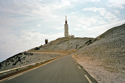
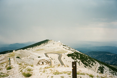
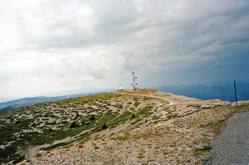
I have heard of all the horrors that could make the climb up Mont Ventoux really hard, like the heat, the wind and flies. One is very exposed to the elements all the time on this mountain. However, everything was as perfect as I could imagine the circumstances to be this day. I felt spoilt and decided that I at least than have to keep a good speed up so I at least would be a little tired at the top. Actually even though the climb did not take longer than 1,5 hour (unfortunately I did not time it – it would have been fun to know for sure), I was not really tired when I arrived at the top. It all felt very easy (maybe because I had such expectations of a hard climb beforehand). The first photo was taken while cycling up the last stretch – pretty nice and a classic view of the antenna up there.
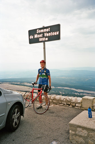
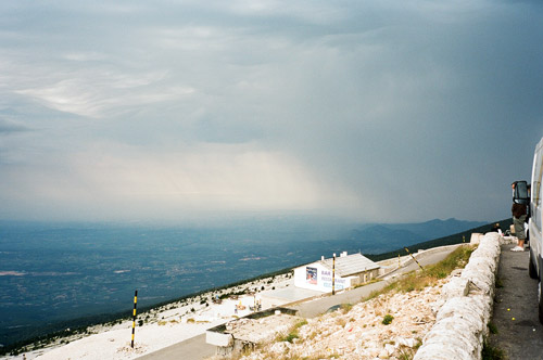
A girl offered to take a photo of me at the obligatory sign at the top and I could not say no to that. I also had a couple of more photos here and a little chat with some english bicyclists up there – telling them it might be an idea to not linger too long here as I saw thunder and lightning not far away coming in our direction. The official height of Mont Ventoux is 1912m (as far as I can make out).
I hurried on down, but did not come longer than to Le Chalet-Reynard (1417m). On the way down there I passed by the second of the French passes that I had to do in order to have climbed all passes above 1700m throughout the Alps (this is actually technically part of the Alps, at least according to Freytag & Berndt’s map of the Alps). The pass is called Col des Tempêtes (1829m).
I continued down toward Sault here, but stopped shortly for the rain hoping to escape cycling through the worst of it. It ceased a bit and I continued down the somewhat wobbly road that descends slowly all the way down to Sault (694m). Down in Sault the temperature was good. Time for a lunch break (sometime before 1 pm for once). I bought some a baguette and finally decided to buy a jar of jam to fill it with. The grocery shop was nearly exploding due to too many customers in the too little shop (just like always in France for all that I know). I sat outside on the pavement in a corner conveniently just under a rain/sun shield as it soon started to rain again (although it was dry here when I arrived). It was a bit tricky getting the orange marmalade out on the bread, but I used my pencil or something and just licked it clean (have to be practical ;-)). It was a good idea with marmalade when they do not have a charcuterie desk.
It is usually much nicer to have lunch like this than sitting at a café or restaurant getting served less fresh/good stuff for a higher price. Occasionally I do this myself too however, so no real argument here (esp. since the shops are not open between ca. 12:30-15:30). Do as you please! When I was done it stopped raining again, so I hoped I would escape the rain now and I did so for quite some time.
Then I was off (I was looking closely on the map to make sure I took the right road) eastwards on a very long and winding road through endless lavender fields. This is a very rural area and everything seem far away from here. It was first 29 km to Banon (790m) (you reach approximately 1000m height on the way there), which was like a nice little oasis and seemed to have attracted a few tourists. Then it was another 18 km to St. Ètienne-les-Orgues (679m), where I stopped again for a sandwich and coke at a café, this time.
Next thing to do was to climb up the “sister mountain” of Mont Ventoux seen in the distance of each other. The negative thing about this new climb is that I was coming in from the boring side (decidedly). Few would want to first go 50 km to climb this from this side, but it was the only thing that made sense given my plan at large. The climb I am talking about is up to Sommet de Lure (1826m) (there seem to be an unnamed pass at 1704m). There is one pass on this road as one descends on the other side to Pas de la Graille/Col de Frère Jean (1597m).
Another problem with climbing the south side of the Lure mountain is that here there are a lot of flies and even if it is not as steep as the north side, you still cannot go fast enough to keep the flies away, especially not as you get higher up where the road is steeper. It is very difficult to see exactly where the road is heading, but you can occasionally see the top of the mountain and you know it is there you are going. One is going through woods up until (and a little beyond) where a road goes off to a chapel. Here the road also starts to change into a bit steeper road. The bit up until here is quite boring and long, but here it starts to get much better and the mountain top is no longer just something on the horizon.
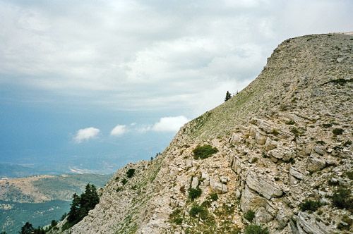
At the station de Lure (some kind of a not very popular ski station it seemed like) one might be able to get something to eat here (I did not stop to look closer). (One can go both ways around this station.) From here the mountain is looking a bit similar to Mont Ventoux (but certainly not as impressive). When you arrive at the highest point of the road (1740m) there is a little road going up to the sommet/top itself. At first it looks too bad to be used with a road bike, but it can be negotiated and the road then becomes better and fully asphalted to the top. There was a family coming up in their car just as I arrived there too. From the top you have really nice views north (very spectacular as the north side is very steep) and you can also see the Mont Ventoux in the distance. It was a nice feeling to see that I had been at the mountain top far away in the distance earlier in the day – it seemed a bit unreal. I really recommend one takes the trouble to go up the last part. (Photos are below.)
At Pas de la Graille/Col de Frère Jean (1597m) you cross a ridge and start on the north side down the mountain. Here the road is maintained by another department (apparently) and it has a different surface and the road is more narrow and steeper with a lot of serpentines down. This road is mostly also through woods, but as it is steep you will have fine views through the trees here and there. The road surface gets more wobbly and rougher the further down you go, but there is no big problem here.
I was a bit disoriented when coming down and asked some girls for a shortcut road to Sisteron near Les Richaud, but I first had to get out on a bigger road for the D53 shortcut to Sisteron.
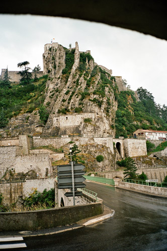
Sisteron (470m) is a very nice city with many old interesting buildings. Here it started to rain again and while I was hiding for the rain I had the last photo for the day (below).
Time was running away and I may not have left Sisteron before 19:00, but I could not stop this early and I had a rather clear idea of how far I needed to go this day. What was not quite as clear, however, was which road to take ahead. I had originally planned to go over more (many more, of course … ) cols: Col du Chateau; Col du Haut Forest; Col d’Espreaux; Col du Festre/d’Agnières; Col des Rioupes; Col du Noyer; Col de l’Holme; Col de Pierre Grosse; Col de Parquetout; Col d’Ornon; Col du Solude and maybe some gravel passes in the area of Le Bourg d’Oisans; Col du Lautaret; Col de l’Izoard and into Italy … . Sure!? But after staying a day in Chamonix and having to use one day before that to make up for bad weather (even though cutting plans short even then everywhere), I just had to abandon the idea of going via Briançon.
The problem with this was that I did not have a map of the road toward the east from Sisteron! Thankfully I have spent a lot of time studying the maps beforehand, so I more or less knew which way to take in order to get to the Barrage de Serre-Poncon (the gigantic dam south-west of Embrun). From there I would know the way ahead. I knew it should be possible somehow to get there by continuing on the road I had originally planned to start out on – the D951 to La Motte-du-Caire.
I went somewhat slow at first as I was hoping the road might be dry further ahead. It stopped raining and the road was soon almost dry anyway. I passed through La Motte-du-Caire (700m) just as the clock passed 8 pm and then a couple who came walking by the roadside said something about that it would soon get dark and that there was no place ahead to stop at (at least that was what I thought they were hinting at). I guess I just said “no problem, thanks” or something while being very unsure about the soundness of going ahead on an uphill road to seemingly nowhere this late.
Eventually I reached Col de Sarraut (980m) and was heading down, hoping things would get clear soon afterwards. But at first I wondered where I was going, since here was another even more lonely valley seemingly surrounded by higher hills and mountains all around. There were a couple of roads taking off to the right, but that I knew must be wrong, so I continued to Bréziers, where I was thinking of trying to find a place to stay at for the night, but it did not look hopeful. Here was a road going in the other direction and even though the direction on the sign did not tell me anything, I knew I had to take it and luckily I was soon down on the main road to Serre-Poncon. The next village there is Espinasses (660m) which I reached just as it was turning dark. I stopped at the first (of the two) hotels, which looked cheap and was so (relatively). I had something to eat there and slept well. (Not a very good hotel, but they were at least friendly and nice.)
