Some facts
This year I decided to make another (perhaps final?) challenge to myself with a plan more unrealistic than ever before. The goal this Summer was to make sure I have climbed every asphalted (at least one side) pass throughout the whole of the Alps above 1700m (which I have detailed in a list at the cycloclimbing.com site (of which this page is part)). I also wanted to include some difficult roads that are not passes.
It was 29 days of cycling, with one rest day (only one pass and 3 hours cycling that day) in Chamonix. Numbers: Length: 4916.7 km for 29 days = 170 km/day (174 km/day discounting the rest day) Height metres climbed: 105454 m for 29 days = 3636m/day (3722m/day for the 28 days). Temperatures from 3°C (and snow on the Grimselpass) to 45°C in the sun near (or in) Lichtenstein (though it felt worst with 41°C in the sun in Bolzano on a 30% steep road with no wind …). These numbers are good (and could have been even better with better weather). Height metres per day is close to the record from 2002 (3798m/day) and then it was only 14 days. New record height metres for one day is now 5651m (which should still be somewhat easy to beat). The average length per day is actually a record too (but not with so much). I think I cycled (for a while) at 30% inclination and thus the steepest climbing I have done (usually my limit is 27% with two front chain rings). Top speed was around 85 km/h (record thus far is only 91 km/h – if I decide to do the Ötztaler radmarathon one day I am sure this could be improved upon down the Kühtai). New record in the Maratona dles Dolomites (my third time), but unfortunately not under 6 hours (which was my goal), with 6h 9m 57secs.
Hardest was of course day number 11 (see that day for more information). Hardest in terms of weather was clearly day 19 with rain most of the day. Hardest single climb must have been the Mölltaler Gletscherstrasse on day 11. Hardest single climb I could not (and no one could) climb was the Oberbozen/Rittnerhorn climb on day 4 and the way to the Mortirolo pass I took on day 15. The highest climb was the Kaunertaler Gletscherstrasse at 2751m. Most beautiful climb was perhaps Rittnerhorn – other beautiful climbs (that were new to me) include: Passo del Cavallino della Fobbia; Bocca di Tratto Spino; Passo Fresna; Klammljoch; Alpe di Siusi; Sella di Rioda; Sölkpass; Mölltaler Gletscherstrasse; Kerschbaumer Sattel; Zillertaler höhenstrasse; Hahntennjoch; Raues Joch (Formarinsee); Kaunertaler Gletscherstrasse; Lai da Vons; Bargällasattel; Chamm (Gonzen/Palfries); Männlichen (would have been nice if I had seen anything at all); Furggu (above Zwischbergen); (Col de) la Forclaz (above Evolène); Col des Posettes; Col de la Colombière (no good weather for a photo though); Col du Coq; Col de la Machine; Mont Ventoux; Sommet de Lure; Colle della Ciabra; Colle della Colma (galleria Rosazza); Bocchetta di Margosio; Alpe di Cadinello (Alpe del Gesero); Vò di Moncòdeno – of these I would single out: Mölltaler Gletscherstrasse; Lai da Vons; Col de la Machine; Mont Ventoux; Colle della Colma (galleria Rosazza); Bocchetta di Margosio and Alpe di Cadinello (Alpe del Gesero).
Best food was in Choranche in the Gorges de la Bourne. Best place to sleep was in Prutz, Austria (also one of the cheapest). Other general information: 4 flats during the ride. One new tyre for the rear wheel was needed as the new Michelin Pro Race 2 tyre wore out on day 16 (they are only good for 15 days cycling! ;-)). Still noises from the bicycle (now and then) and I think I know of some possible causes now (aluminum seat post in carbon frame might be a bad idea; Tune rear wheel cassette body is too narrow; possible change of bottom bracket bearings needed; and also a sign of a crack in the rear rim). New HAC 4 Pro (changed), can be unreliable (it can forget it is mounted on a bicycle in a strange way not clearly related to battery life and can show very high speed when the bicycle is parked – I believe this is true of every unit they have manufactured). My favourite tyre is Michelin Krylion. For inner tubes, Michelin and Schwalbe are the best. I bought a new pair of Speedplay pedals for this year, but felt they were no good for this type of cycling (a bit like using carbon wheels for gravel road cycling) and used the reliable SPD-SL pedals instead. I skipped a lot of planned difficult gravel roads mostly because of bad weather (a good side effect of having bad weather ;-)). I had a new Deuter backpack Race X Air similar to the one I used back in 2002-3, but now with built in rain protection and some other design changes. – I have reported some weaknesses in the model (the front zipper and unnecessary heavy weight), but Deuter does not seem to appreciate customer feedback. This is a bit heavier than the model I used the previous years, but it is worth it as it sits much better and is less warm. One has to use a scissor to cut the pointless waist straps and reduce the length of the ‘whips’ that adjust the height position.
Note: Please do not use Internet Explorer for watching these pages – if you have a Windows-PC I would recommend you download and use a good browser like Opera, Chrome, Safari or Firefox. These pages looks best in Safari on a Mac (where you will likely have the Optima and Goudy Old Style fonts, colours are also a pinch better).
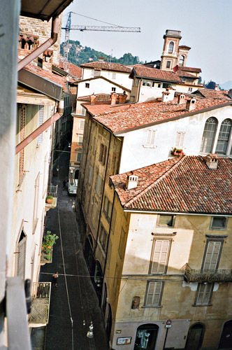
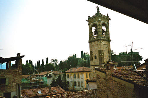
The tour started (June 25th) and ended (July 23rd) in Bergamo – a mid-sized town in north of Italy located just at the feet of the Alps. It is a somewhat bleak town, but it has a very nice old city centre – Città Alta – where I found a quite good Bed & Breakfast. La Torre B&B is located less than 100m away from the funicolare (steep cable rail service) that connects with the lower modern city and here one can get directly to/from the airport with bus no. 1 (get the right ticket!). The stay here was enjoyable and the nice brothers running the place was kind enough to let me leave my big bicycle bag there for a whole month. The first photo (overlooking the main street in the old city) & the next (in the other direction) above was taken from my window (seen highest in a photo on the website linked to).
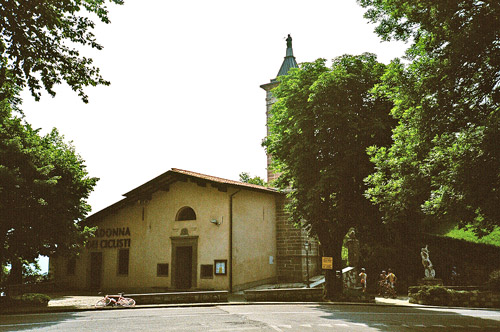
The ride started with long stretches of cobblestones out of the city. It was a hot day already from the start. The first mountain pass came after less than 20 km – Colle del Gallo (763m). This was a nice pass with a church (Madonna dei Ciclisti) for cyclists at the top (I never went in – perhaps I should have …). The brothers at the B&B told me about this and it seemed appropriate to get some blessings on the way at the start of the tour! :-)
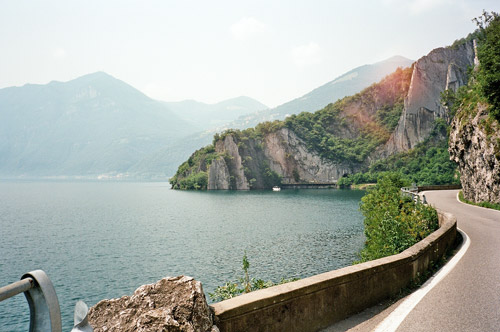
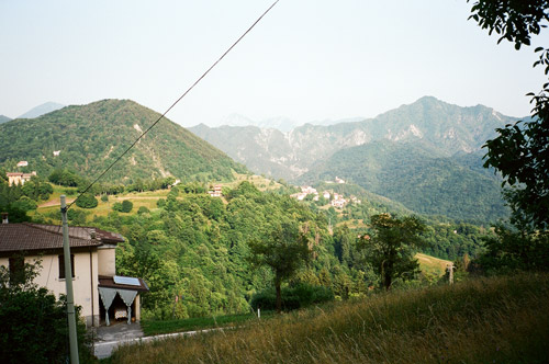
There were more and somewhat tight serpentines down the other side to Lago (lake) di Endine. This lake is good to pass on the east side to avoid the traffic on the main road. I then took the road over Solto Collina (arguably a little pass too, but with no official name, I believe) to Riva di Solto. From here it is very beautiful along the narrow road up to Castro by the Lago d’Iseo. Next photo was taken on this stretch, where I also talked a little with a local cyclist.
I was on my way to Pisogne (187m). From there (after some confusion) I found the road up to Passabocche (1297m, highest point 1323m). It is the same road at the start that goes to Pelotto/Val Palot and Colle San Zeno (1434m). This road is really steep and eventually I found a place to fill up water in the heat on this climb. Only problem was that someone had written by hand ‘Non potable’ (not drinkable), but someone else had then crossed over “Non” and instead written “Uno” (drinkable once). I thought I should only need to drink once, so I filled the bottle! ;-/ (I was really thirsty, so I took the chance.) Later I even decided to stop on this climb and had a sandwich at a bar in Grignaghe. You will need to either forget about maps and you will probably find the right road as long as you take off right at an obvious place far above Pisogne, or you have to get Kompass 103 (I think it is the only map actually showing this road as it goes, though it looks like a gravel road in part on the map, which it is not). There is actually one more pass after a little climb and descent – Foppello Croce Marino (1285m) (this name may be a construct by Italian cyclists, but it is a pass for sure). Even if I stopped on the way it was still a hard pass to climb!
Then I came down to Pelotto/Val Palot (1043m) on the road up to Colle San Zeno (1434m). This road is not shown as asphalted anywhere and I could not find any information suggesting otherwise on the web or elsewhere. This interesting mountain pass road is however fully asphalted (apart from a little work on a house at the top which meant 10m was gravel when I passed by. This pass is easier than the Passabocche (even if salite.ch indicates otherwise) and not as nice on the Pisogne side. The San Zeno pass is quite nice on the Lavone (east) side!
Down at Tavérnole sul Mella (471m) in Val Trompia, I stopped to eat something I bought at the grocery store there (good place to stop, with benches in the shadows opposite to the shop). It was a nice climb over Marmentino and the passes: Passo del Santellone (873m), Passo del Termine (954m) and via a short detour in the direction of Pertica Bassa up a steep road and back the same way to Passo della Santa (941m). (One should also pass over a small pass on the way down to Nozza (300m) and Vestone (320m) – Le Cucche (460m).)
Another small stop in Vestone before I went up the (not signposted) road (SP56) to Treviso Bresciano. This small road is a hard climb up to Valledrane (786m). Valledrane is a nice viewpoint reached by taking off the SP56 at the highest point and continue up for another kilometre – the next to last photo on the page is from this little road. After a short descent one climbs into the small village of Treviso Bresciano. After the village this road becomes very steep up to the highest point at Cavacca (1102m). At a crossroad one encounter Passo del Cavallino della Fobbia (1080m). I had thought the road that climbs up from here should be asphalted toward Cocca Manos (1333m), but unfortunately it was a bit bad gravel road and I turned around rather quickly as it was getting late and I did not know for sure that there would be asphalt down the other side of this forest road, but I believe there might be asphalt up on the other side of one the passes up there as it is not noted as a gravel road in the Club des Cent Cols’ pass catalogue for the area.
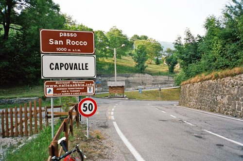
The narrow asphalt road down to Capovalle is quite nice however (probably much nicer than the forest road higher up). At one point one goes through a little church building on the way down. Then I had a short climb up the wide and good main road to Capovalle and Passo di San Rocco (946m) (last photo). From here it is a gently sloping road down by a huge dam (Lago di Valvestino) to Gargnano by the Lago di Garda (the last stretch is quick down through serpentines).
I used the tourist information telephone (outside) to book a hotel there (only time ever I used a tourist information facility for getting help with anything). I had a decent room at a well-located hotel in Gargnano and went down to have some really good food at a restaurant on a side street. Afterwards I also had some very good ice-cream at a gelateria nearby (some other restaurant guests also afterwards took that route for dessert … ).
