I did not have any breakfast, but then also got on my way decently early somewhat after 8 in the morning. It was not totally dry after some rain in the early morning and that made me a bit worried as I was about to get up on gravel roads above Guillestre (around 1000 m). I hoped that it would be dry by the time I reached the gravel though and started slowly going up to Risoul ski station and village above the town. The road up there has recently been improved with EU money and could possibly be one of the smoothest roads in all of Europe. It is very many hairpins at first among scattered buildings and small villages and later in a forest.
Up in the forest not too long from Risoul 1850 m, I met a van coming down honking at me and I wondered what was up (did they want to warn me that this was not a good road to take?). It turned out it was Bernard Girardeau of Club des Cent Cols, who recognized my Cent Cols jersey and stopped. We talked a little and he explained he worked in Risoul half of the year and the other half on Corsica – rather ideal for a cycloclimber! He did not think Col de la Valbelle and the gravel roads above Risoul would present much of a problem to me.
Arriving in Risoul the roads were no longer nice and the village looked like a construction site (like many Winter resorts do in the Summer). They had a big tourist office and I thought I should take a look and see if they had any detailed map of the area, which they have for free. They were not helpful (of course) and they suggested that it was no idea for me to get up there with a road bike. The idea of using a road bike for touristic purposes is never part of a tourist professional’s worldview; it is as simple as that. In fact I think it is anathema to them (at least in most places of the world) as road bike cyclists are not the ideal high-spending tourists they envisage as proper ”tourists”. And, well, that is part of the reason it is preferable to be a tourist on a road bike, since you will not deal directly with the tourist industry. (I am not against it – it is simply just not for me.)
The map was of some help, but I still had to ask a local old man of the road to take, who contrary to the tourist office actually was helpful despite that he did not understand English like the ”tourist Pros” did (no surprise). There are plenty of gravel roads above Risoul going in all directions, so a map tourist office would be advisable. (You should turn right after the tourist information and then essentially go as straight up as possible. Look out for lift cables; you should stay somewhat near them.) The gravel road was totally cyclable for me on the road bike and was only occasionally a bit difficult, just as Bernard had suggested. It was also dry from Risoul and here on.
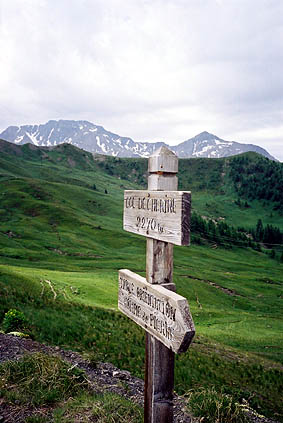
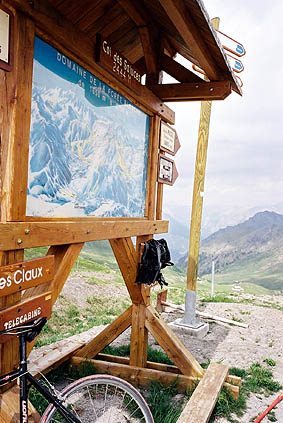
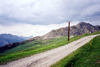
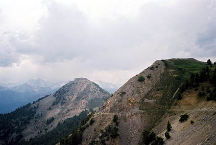
I first went out on a ledge to Col de Chérine 2270 m. Then back to climb the last part up to Col de la Valbelle 2372 m. (One could continue following the sign you see in the photo in order to get a better view out over Guillestre and the surrounding mountains). From this col you can continue down or you can go up to the left. I went up to the left (very difficult to cycle the first steep ramp – I managed with some luck to do it). Then you soon arrive at another col, the Col du Vallon 2466 m. From here you can still continue to yet another col, but it is on a road that does not look very much used and you would probably think twice about continuing there unless you knew it was worthwhile. And I can tell you it is worthwhile and it is possible to cycle all the way, which is only about a kilometre. At Col de Saluces 2444 m you have much better views than from the other cols up here that I visited. You will see the Refuge Napoléon in the distance (it is there in the photo, but hard to see).
One thing I did not know was that the road continues from Col de Saluces, but it looked very muddy. After some dry days, it might be rideable and maybe it will take you down toward Col de Vars (it looks that way). I know there should be continuations toward Col de Parpaillon, but I believe you will soon have to strike off this road and walk on paths instead.
I returned to Col de la Valbelle and this time crossed over to the west and down. You can see an unsurfaced road going here on the Michelin local maps and on the viamichelin.com web site. It is a through-road that becomes tarmacced at the next col – Col de la Coche 1791 m. It is however not a very good road. I could cycle most of it even though it was very rough here and there. It got a bit better in the woods. But before there, I had to ford a small stream running over the road at one place. I tried to find a place to be able to walk over without getting wet, but finally had to take off my shoes and walk over carefully. I met one or two people on motorcycles and maybe they managed to go over without getting too wet, but it did not look obvious that you could easily pass on a motorcycle. I met a local motorcyclist that warned me of some danger ahead later on, but did not quite understand the word, even though I had heard it before. It was probably a drainage gully later on the tarmac road that appeared very suddenly after a bend and could very well prove a hazard on the steep road down. I was a bit cautious while going down so I had no problem.
There was a nice and lonely road down to the main road going back up to Guillestre. I took the main road all the way to Briançon as it had taken a lot of time to travel the gravel roads earlier. Well in Briançon I had a sandwich at a bar near to where the road up to Col d’Izoard starts. I looked for a place to fill my water bottle, but did not believe the fountain in the centre of the town was any good and hoped to find a place on the way up toward Col d’Izoard, which I did not. This was a bit worrying, as I had heard there should not be much water on the way to Col des Gondrans, where I was heading. With a half-filled water bottle I finally found the right place to turn off the Col d’Izoard road. (Maybe one could take the first paved road going to a fort also, but you should take the first road going left after passing by a quarry of some kind.)
The road up to Col des Gondrans 2347 m is sort of paved, but is very patchy and not good. It is quite nice however. It is also very hot and dry and it turned out to be a real struggle against too little water to climb this road. At least one full 0,75 l water bottle is mandatory for this road! I am known in my cycle club at home too drink too little, but half a bottle up this pass should be too little to anyone. I could only try and keep my lips somewhat moisturized and felt like I was in an endless desert. It is funny how the weather conditions could vary in these mountains. Up to Risoul it was so wet in the air, I did not really need to drink at all.
I just about managed to reach the top of the pass without passing out. I had to refill my water bottle at one of the suspicious looking water outlets up there, but decided only to drink as much as I had to in order to get safely down again.
At the top of the pass (where the tarmac ends, I believe) you have a nice view of the Janus fort nearby, which one could visit as well (but I felt there was not time for it). I wanted to visit another +2000 m col not so far away. Just when the road flattens out, there is a road going left (when coming up the Col des Gondrans road). This looked fine at first and seemed to be spectacular. According to a map I had seen it could also be possible to continue this road all the way down to Briançon. After getting around the first mountaintop I saw clearly where the col was and that it led to the l’Infernet fort. However, I now felt a few rain drops in the air and suddenly the road had disappeared due to a landslide and there was only a path for several hundred meters in the loose mountainside and I decided it was all a bit too adventurous to try this out totally alone up there. Especially so since it was now around 18 in the afternoon and I had to be in La Grave before the night to meet a friend there at a booked hotel.
I had also planned to go up the Col de Granon on the way to La Grave, which now was pure lunacy even to think of. La Grave is not exactly nearby. My minimum goal for this year’s tour was to have climbed all tarmacced passes in the Alps above 2000 m and Col de Granon was one of them. So the situation was not ideal, but I had to think of whether or not to try and amend my plans later in the tour in order to be able to get up this col also.
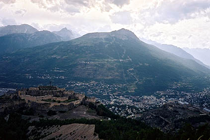
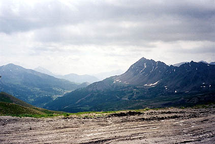
It never started to rain thankfully and I stopped at around 2000 m height on the road down where a road is going right (this might actually be a fully cyclable alternative road down (gravel mostly) and there were a nicely short paved road going up which made me curious, but it seemed to go to a private house there). I got a very good view only a few meters into this road for a photo of two forts and Briançon all at once here.
In Briançon I stopped at the McDonalds to eat (it is not easy to find better alternatives in that town). What you eat is not very important as long as you get something to eat while on tours like this. You do not exactly stand a chance of getting fatter. – If you do, you will have to make more ambitious tour plans!
It was sunny and did not look like the night was coming anytime soon, but I knew I had to look on my watch a little. It was 19 p.m. when I got out of Briançon and now it was all a matter of not getting too late to La Grave for to have something more to eat and be accepted at the hotel and find my friend. Now I remembered from 2002 that even though if the road to Col du Lautaret 2057 m from Briançon 1204 m is rather easy and is never above something like 6%, it is a curious exception to the rule of the way the wind blows in passes. One usually has the wind in the back on the way up most passes in the Alps (on both sides), but never on this one (I got corroborating evidence from other people I talked with about this pass). So it was a long slog up the pass with increasing wind, coldness and steepness. I finally reached the pass two hours later. Now the sun was setting and I hurried down to La Grave.
It only took another 15 minutes to reach La Grave and the hotel. The hotel is called Castillan and is on the main road in the centre of the village. The hotel was quite good and I appreciated the nice somewhat old-fashioned lady who was polite and helpful. Oddly enough I did not find my friend. He had walked out to eat I learned (surely he could not wait all night for me), but the odd thing was that I could not find him at the restaurants in the village and I decided to stay at a pub with a lot of people watching the world championship in soccer/football to eat and have a few beers.
Day 1 – Day 2 – Day 3 – Day 4 – Next Day – Day 6 – Day 7 – Day 8 – Day 9 – Day 10 – Day 11 – Day 12 – Day 13 – Day 14 – Day 15 – Day 16 – Day 17 – Day 18 – Day 19 – Day 20 – Day 21 – Day 22 – Day 23