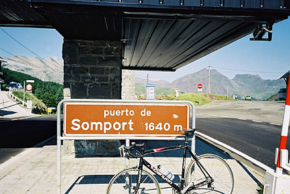
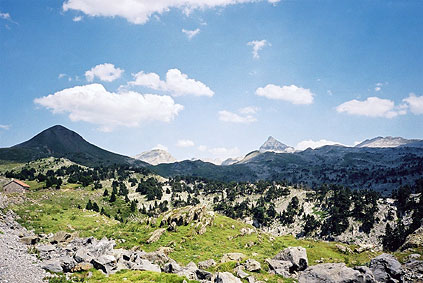
Another hot day, but with a nice start up to the Somport pass. It seemed like I was loosing the effect now of the race some days ago and I was back to just normal tiredness in addition to added effect of getting worn down over the days of hard cycling. It still feels natural to keep on cycling and especially up among nice mountains in fine weather. Col du Somport (1632) was not so difficult, but then I started half-way up the climb from Jaca (but it is not a very hard climb anyway). It is nice at the pass with purple mountains, but a little less nice than at the Portalet pass.
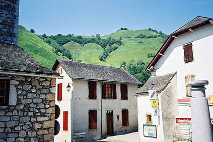
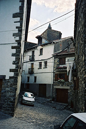
Back in France for some time. I went off the road to Osse-en-Aspe (453) and had an early lunch by the local grocery (buying some fruit cake, fruits and soda). I took a photo from where I sat outside the shop as it looked quite pretty with this tiny village and its tiny square and tiny crossroad wrapped in the tightly surrounding low mountains (2nd photo).
The tiny road (there are two alternatives) that you see in the photo climbs very steeply up the hillside to Col de Houratate (1009) in just something like 7 km. From this pass an even tinier paved road continues up even steeper (and has a last pull with around 20%) up to Col de Bergout (1164), where the asphalt runs out. I had a photo and returned down and went on west on a nice road to Col de Labays (1351). This road first goes down and also takes in another pass called Col de Bouesou (1009), then it is a quite hard paved forestry road up to Col de Labays (from 911 metres height) with plenty of stinging insects making sure you will loose your good temper. There is no water along this road and no place to buy anything.
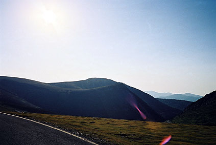
At Col de Labays I was very tired, but could not get any rest there as the place was the local hang-out place for the worst flies in the area (in the whole of the Pyrenées perhaps). When starting out the climb from Jaca the day before, I encountered some very big flies with large wings that looked like big butterflies that I had to duck for, but they did not bite me at least. I continued up the next crossing road between France and Spain, but after arriving at Col de Soudet (1540), I took a road going down west. (On the short way up to Col de Soudet, one also passes Pas de Guillers (1436) and Pas de Lamayo (1450) without any extra effort.)
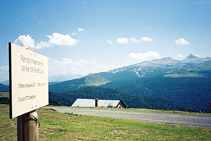
This road going down west is rather steep down to a crossroad, which is also a pass again – Col de Suscousse/Garateko Lepoua (1216). From here I went up to the ridge you saw from the Soudet pass to the north-west, where there are at least these road passes you can get to: Col de Ste Gracie (1325); Col de Lataillade (1425); Col de la Hourcere/Murkhuillako Lepoua/Izarbe Lepoa (1445). I tried to find a sign for the highest of these passes, but only found the path sign in the photo from that place (looking in the direction of the Soudet pass and the border to Spain).
Then after this pass collecting, I returned back again to the road over to Spain. The landscape up around this pass road is rather unusual and the pass road is very undulating and odd too, probably since finding a good way over this pass was not easy given the rock formations. They have funny warning signs off the road side warning people from jumping from rock to rock out there as there could be deep clefts in between!
There are several passes both on the road itself and not far from the road. Up to the highest pass – Col de la Pierre St Martin (1760) you pass also Pas de Massare (1655) and Pas d'Arlas (1698). After the pass, which is pretty high for this area and there is not much mountains tops reaching 2000 metres west from here in the Pyrenées, you will pass another two passes: Col de Couma Longa (1605) and Erraizeko Lepoua/Portillo de Eraice (1578). This is thus one of the most pass-filled roads and areas in the Pyrenées.
The road makes a full circle crossing under itself on the Spanish side, just like some train lines in mountains sometimes do as they cannot go too steeply and avoids it that way. But here it is obviously the odd terrain that was the main problem. The road is somewhat flat around the top section for some time before eventually dropping down into Spain.
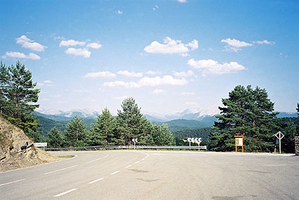
In a short time you will arrive down at Isaba (890), which is a pretty little village popular with tourists, apparently. I bought some pastry and icecream at a shop. I had a photo there also.
The road going west via Uztárroz is flat, very good and nice. There is then an easy ascent to Portillo de Lazar/Alto Laza (1129). Moderately scenic at the top. I continued quickly down to Ochagavía (755), where I stopped briefly before taking a road north, which was surprisingly flat for a long time. This is the road going over Paso Tapla/Tapia (1364) and to the forest of Iraty. The climb up Paso Tapla is not difficult and rather sweet in its solitude, but exposed to the sun on the south side. There are some cars – usually with people going over to the forest for taking walks in the area. The north side of the pass is really nice and is a good road until the bottom, where the asphalt ends and you are presented with a couple of gravel roads to choose from.
I took the one seeming to be the one I intended to take on the left side of the river toward France. (Take right after a water tap.) I had spotted a path continuing this road and that there should be a bridge over the river later on. I continued the gravel road until it ended near the riverside. Here 4-wheel drive vehicles had apparently driven right over the shallow river to the other sie, but as I thought there was a bridge ahead I continued on the path (soon having to walk).
However, I did not spot any bridge and the path kept climbing up the hillside (and sometimes down again) and it got splitting up into alternatives paths and I had to guess the one to take. I tried to take the one going closest to the river all the time, but eventually this path became very narrow and fainter and the hillside so steep it was getting slightly dangerous and more difficult to proceed. At one place I de to return and take a higher level path, which still ended up the same way, but I decided to proceed and hoped to find the road that should end at the border on this side of the river and be paved all the way according to maps.
I was close to give up and return back and take either a very much higher level path or go back to where the road ended and cross the river there (might be the best to do if you take this way). After dragging my bicycle up a very steep hillside on a tiny path I came to a place where I had to hurl my bicycle up on a rock above and thereafter climb up myself. I thought that if there would be more of this I would definitely return, but just as I climbed up this last little obstacle I found myself just at the end of the road I was looking for to my surprise (not possible to see before you actually stand on it).
The road is never used up to the end by cars apparently as it was all grown over with grass, but could be driven down and I passed by some bird-watcher (I think) who must have been surprised seeing me coming down on my road bike there. Soon one does get down to a crossroad/bridge, but here one should not cross (supposing one would want to stay on tarmac and go the easy way north.
The road goes a little up and down to the crossroads at Iratyko Etchola (1000). From here it is a nice touristy forest road up east to the Les Chalets d'Iraty – the main office which is found at the Col Bagargiak/d'Iraty (1327) (which is soon after another pass, Col Heguichouria (1319)).
I managed to find someone who could get me a bed in a nearby chalet (nice-looking buildings, but very simple youth hostel like). The price was very low (like 15 euro or so) however and I even got a room of my own. But I had nothing night linen and only a cotton cover for the pillow (which I used to dry myself with after showering one floor below). I had a sandwich and some beers in the nearby restaurant. It was a nice night, but I went to bed somewhat early, but it was not very comfortable to sleep there.
Day 1 – Day 2 – Day 3 – Day 4 – Day 5 – Day 6 – Day 7 – Day 8 – Day 9 – Day 10 – Day 11 – Day 12 – Day 13 – Next Day – Day 15 – Day 16 – Day 17 – Day 18 – Day 19 – Day 20 – Day 21 – Day 22 – Day 23 – Day 24 – Day 25 – Day 26 – Day 27